IMAGES TAKEN NEAR TO
Sleeper Close, NG9 2XF
Introduction
This page details the photographs taken nearby to Sleeper Close, NG9 2XF by members of the Geograph project.
The Geograph project started in 2005 with the aim of publishing, organising and preserving representative images for every square kilometre of Great Britain, Ireland and the Isle of Man.

There are currently over 7.5m images from over14,400 individuals and you can help contribute to the project by visiting https://www.geograph.org.uk
Image Map
Images are licensed for reuse under creativecommons.org/licenses/by-sa/2.0
Notes
- Clicking on the map will re-center to the selected point.
- The higher the marker number, the further away the image location is from the centre of the postcode.
Image Listing (409 Images Found)
Images are licensed for reuse under creativecommons.org/licenses/by-sa/2.0
Image
Details
Distance
1
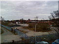
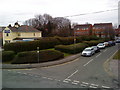
Development near Beeston Station
This area is undergoing construction for 40-42 modular homes by ilke Homes. The site was formerly owned by Network Rail and sits adjacent to the Midland Main Line.
Image: © Pierre Marshall
Taken: 9 Oct 2021
0.01 miles
2
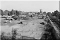
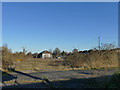
Former Blue Circle cement depot, Beeston
The Blue Circle cement depot in Beeston was closed in the early 1990s. The loading towers were demolished shortly afterwards. The remaining buildings are part of the original Midland Railway goods depot.
Image: © Andrew Abbott
Taken: 22 Mar 2010
0.02 miles
3
Development near Beeston Station
Further construction of the ilke Homes development adjacent to the Midland Main Line.
Image: © Pierre Marshall
Taken: Unknown
0.02 miles
4
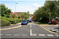
Waterloo Road
A cul-de-sac off Station Road
Image: © David Lally
Taken: 14 Jul 2011
0.02 miles
5
Waterloo Road, Beeston
Waterloo Road in Beeston. The yellow building on the left was the former station master's house, erected by the Midland Railway in 1871. It formerly stood as the station master's house at Southwell, but was moved here in 1871 when Southwell station was rebuilt. It is now used as a day nursery.
Image: © Andrew Abbott
Taken: 22 Mar 2010
0.03 miles
6

City Card Cycle stand
Outside Beeston Station.
Image: © David Lally
Taken: 29 May 2015
0.03 miles
7
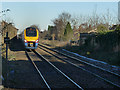
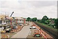
Meridian unit at Beeston
A "Meridian" unit no. 222011 departs from Beeston station with the 12.10 London St Pancras to Nottingham service.
The goods yard at Beeston has lost all its tracks but the pre-WW1 goods shed (left) survives.
Image: © Stephen Craven
Taken: 19 Jan 2020
0.03 miles
8
Former goods yard, Beeston station
The goods yard at Beeston has lost all its tracks but the pre-WW1 goods shed survives.
Image: © Stephen Craven
Taken: 19 Jan 2020
0.04 miles
9
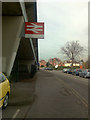
Station Approach, Beeston
This approach road to Beeston Station actually appears to be unnamed. I suppose that it is Station Road, but that name is now shared by the main carriageway which climbs the bridge
Image: © David Lally
Taken: 16 Mar 2009
0.04 miles
10
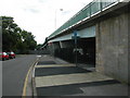
Meadow Road bridge and Beeston station
Meadow Road bridge taken from Station Road, with Beeston station sign. Three forms of transport all in one place, the underpass at the end of the wall on the right is Sustrans national route 6.
Image: © Peter Shone
Taken: 17 Sep 2005
0.05 miles