IMAGES TAKEN NEAR TO
Wallett Avenue, NOTTINGHAM, NG9 2QR
Introduction
This page details the photographs taken nearby to Wallett Avenue, NG9 2QR by members of the Geograph project.
The Geograph project started in 2005 with the aim of publishing, organising and preserving representative images for every square kilometre of Great Britain, Ireland and the Isle of Man.

There are currently over 7.5m images from over14,400 individuals and you can help contribute to the project by visiting https://www.geograph.org.uk
Image Map (Loading...)


Getting Data...Please wait
Leaflet Map data © OpenStreetMap
Images are licensed for reuse under creativecommons.org/licenses/by-sa/2.0
Notes
- Clicking on the map will re-center to the selected point.
- The higher the marker number, the further away the image location is from the centre of the postcode.
Image Listing (56 Images Found)
Images are licensed for reuse under creativecommons.org/licenses/by-sa/2.0
Image
Details
Distance
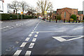
1
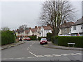
Where the money is kept?
Wallett Avenue, Beeston.
Image: © Alan Murray-Rust
Taken: 4 Apr 2014
0.04 miles
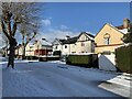
2
Clifford Avenue, Beeston
This road forms part of the ex-council estate which sits between Woodside Road, Derby Road and Wollaton Road. The majority of houses are now privately owned and the area is mostly 'trouble-free'.
Image: © David Lally
Taken: 30 Jan 2008
0.05 miles
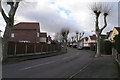
3
Clifford Avenue, Beeston
From the junction with Hetley Road.
Image: © Andrew Abbott
Taken: 25 Jan 2021
0.06 miles
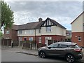
4
6-12 Heeley Road, Beeston
A row of terraced houses
Image: © Andrew Abbott
Taken: 25 Mar 2020
0.07 miles
5
Boundary Road, Beeston
The Beeston United Reformed Church sits on the junction of Boundary Road and Wedsor Avenue. The boundary between The City of Nottingham and (what is now) The Borough of Broxtowe runs next to this road (both sides are in Broxtowe).
Wensor Avenue to the right is bisected by the boundary, which is subject to no sign or change in architecture.
Image: © David Lally
Taken: 30 Jan 2008
0.08 miles
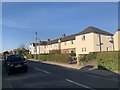
6
1-3 Clifford Avenue
Housing from the 1920s.
Image: © Andrew Abbott
Taken: 18 May 2020
0.08 miles
7
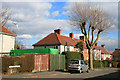
Domestic wind turbine
The house to which it is attached will have a Central Avenue address.
Image: © David Lally
Taken: 4 Mar 2010
0.08 miles
8
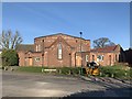
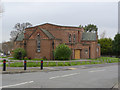
Boundary Road United Reformed Church
Lenton Abbey Congregational Church congregation formed in 1929. Church opened in 1933. Later renamed Boundary Road United Reformed Church. Closed 2010.
Image: © Andrew Abbott
Taken: 25 Mar 2020
0.09 miles
9
Beeston United Reformed Church
Originally a Congregational Church. Some of the brickwork patterns and the glazed tiles are typical of the Art Deco period.
Image: © Alan Murray-Rust
Taken: 4 Apr 2014
0.09 miles
10

Central Avenue
The shot was taken from a short dead-end section in which Central avenue starts. Looking north to the crossroads with Clifford Avenue.
Image: © David Lally
Taken: 4 Mar 2010
0.09 miles