IMAGES TAKEN NEAR TO
Farfield Grove, NOTTINGHAM, NG9 2PW
Introduction
This page details the photographs taken nearby to Farfield Grove, NG9 2PW by members of the Geograph project.
The Geograph project started in 2005 with the aim of publishing, organising and preserving representative images for every square kilometre of Great Britain, Ireland and the Isle of Man.

There are currently over 7.5m images from over14,400 individuals and you can help contribute to the project by visiting https://www.geograph.org.uk
Image Map
Images are licensed for reuse under creativecommons.org/licenses/by-sa/2.0
Notes
- Clicking on the map will re-center to the selected point.
- The higher the marker number, the further away the image location is from the centre of the postcode.
Image Listing (69 Images Found)
Images are licensed for reuse under creativecommons.org/licenses/by-sa/2.0
Image
Details
Distance
1
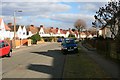
Farfield Avenue
Just off the northern end of Wollaton Road, Beeston.
This is part of a medium size municipal housing estate from between the wars. The border between The Borough of Broxtowe and The City of Nottingham passes pretty much unnoticed through the eastern side of the estate as it approaches Woodside Road and the district of Lenton Abbey.
Image: © David Lally
Taken: 4 Mar 2010
0.05 miles
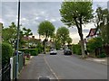
2

Central Avenue
The shot was taken from a short dead-end section in which Central avenue starts. Looking north to the crossroads with Clifford Avenue.
Image: © David Lally
Taken: 4 Mar 2010
0.06 miles
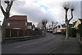
3
Clifford Avenue, Beeston
Developed in the 1920s.
Image: © Andrew Abbott
Taken: 18 May 2020
0.07 miles
4
Domestic wind turbine
The house to which it is attached will have a Central Avenue address.
Image: © David Lally
Taken: 4 Mar 2010
0.07 miles
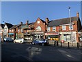
5
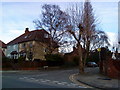
Junction of Wollaton Road and Clifford Avenue, Beeston.
A view of the junction of Wollaton Road and Clifford Avenue, Beeston. This is just about the highest point on Wollaton Road.
Image: © Andrew Abbott
Taken: 28 Mar 2010
0.11 miles
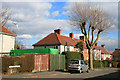
6
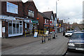
Central Avenue shops, Beeston
This small line of estate shops (including a sub-post office) appears to be surviving the ravages of the 21st century up to now.
Image: © David Lally
Taken: 30 Jan 2008
0.12 miles
8
Clifford Avenue, Beeston
This road forms part of the ex-council estate which sits between Woodside Road, Derby Road and Wollaton Road. The majority of houses are now privately owned and the area is mostly 'trouble-free'.
Image: © David Lally
Taken: 30 Jan 2008
0.13 miles
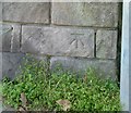
9
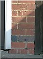
Bench mark, 220 Wollaton Road, Beeston
See http://www.geograph.org.uk/photo/5122751 for location.
Image: © Alan Murray-Rust
Taken: 18 Sep 2016
0.13 miles
10
Bench Mark, Wollaton Road at Old Drive
See http://www.geograph.org.uk/photo/5122755 for location.
Image: © Alan Murray-Rust
Taken: 18 Sep 2016
0.13 miles