IMAGES TAKEN NEAR TO
Queens Road East, NOTTINGHAM, NG9 2GS
Introduction
This page details the photographs taken nearby to Queens Road East, NG9 2GS by members of the Geograph project.
The Geograph project started in 2005 with the aim of publishing, organising and preserving representative images for every square kilometre of Great Britain, Ireland and the Isle of Man.

There are currently over 7.5m images from over14,400 individuals and you can help contribute to the project by visiting https://www.geograph.org.uk
Image Map
Images are licensed for reuse under creativecommons.org/licenses/by-sa/2.0
Notes
- Clicking on the map will re-center to the selected point.
- The higher the marker number, the further away the image location is from the centre of the postcode.
Image Listing (314 Images Found)
Images are licensed for reuse under creativecommons.org/licenses/by-sa/2.0
Image
Details
Distance
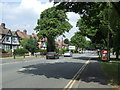
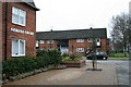
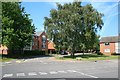
4
Queens Road, Beeston
A very standard tween-wars suburban main road providing a straightforward way past the commercial centre of Beeston.
Image: © Alan Murray-Rust
Taken: 27 Jan 2008
0.04 miles
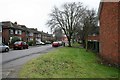
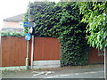
5
Serina Court
At the junction of Tattershall Drive and Queens Road.
Image: © David Lally
Taken: 19 Jan 2010
0.04 miles
6
Tattershall Drive
Tattershall Drive is an "L" shaped road between Queens Road and Hassocks Lane.
This looks along the shorter section toward Queens Road.
Image: © David Lally
Taken: 19 Jan 2010
0.04 miles
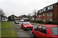
7
Tattershall Drive
Tattershall Drive is an "L" shaped road between Queens Road and Hassocks Lane.
This is looking along the longer section parallel with Queens Road. The new Highfields Fire Station can be seen at the end of the road.
Image: © David Lally
Taken: 19 Jan 2010
0.06 miles
8
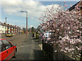
Salisbury Street, Beeston
With a beautiful Magnolia.
Image: © David Lally
Taken: 31 Mar 2009
0.07 miles
9
The junction of Tattershall Drive and Hassocks Lane
Behind me is the new Highfields Fire Station. Image is an opposing view.
Image: © David Lally
Taken: 2 Sep 2010
0.07 miles
10
Cycle path between Lower Road and Fletcher Road
Image: © Andrew Abbott
Taken: 13 Jun 2010
0.08 miles