IMAGES TAKEN NEAR TO
Hassocks Close, NOTTINGHAM, NG9 2GH
Introduction
This page details the photographs taken nearby to Hassocks Close, NG9 2GH by members of the Geograph project.
The Geograph project started in 2005 with the aim of publishing, organising and preserving representative images for every square kilometre of Great Britain, Ireland and the Isle of Man.

There are currently over 7.5m images from over14,400 individuals and you can help contribute to the project by visiting https://www.geograph.org.uk
Image Map
Images are licensed for reuse under creativecommons.org/licenses/by-sa/2.0
Notes
- Clicking on the map will re-center to the selected point.
- The higher the marker number, the further away the image location is from the centre of the postcode.
Image Listing (299 Images Found)
Images are licensed for reuse under creativecommons.org/licenses/by-sa/2.0
Image
Details
Distance
1
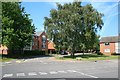
The junction of Tattershall Drive and Hassocks Lane
Behind me is the new Highfields Fire Station. Image is an opposing view.
Image: © David Lally
Taken: 2 Sep 2010
0.03 miles
2

Highfield Fire Station
Taken from Tattershall Drive
Image: © David Lally
Taken: 19 Jan 2010
0.04 miles
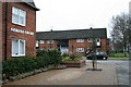
3
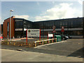
Highfields Fire Station
The new Fire Station on Hassocks Lane, Beeston.
According to a news item on the services' web site dated 3rd Feb, the station was to be officially opened on the 10th by HRH The Princess Royal. There is however no news item about the opening yet (as of 31st March) so I wonder if she stood them up!
Crews from Beeston http://www.geograph.org.uk/photo/318310 and Dunkirk http://www.geograph.org.uk/photo/318315 stations have moved here.
Thanks to Harvey Pryor for finding this link about the opening http://www.beestonexpress.co.uk/images/beestonexpress/Feb20pdfs/Feb20p1.pdf
Image: © David Lally
Taken: 31 Mar 2009
0.04 miles
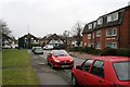
4
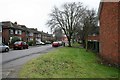
Tattershall Drive
Tattershall Drive is an "L" shaped road between Queens Road and Hassocks Lane.
This is looking along the longer section parallel with Queens Road. The new Highfields Fire Station can be seen at the end of the road.
Image: © David Lally
Taken: 19 Jan 2010
0.05 miles
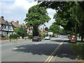
8
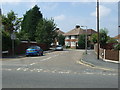
Tattershall Drive
Tattershall Drive is an "L" shaped road between Queens Road and Hassocks Lane.
This looks along the shorter section toward Queens Road.
Image: © David Lally
Taken: 19 Jan 2010
0.08 miles
9
Serina Court
At the junction of Tattershall Drive and Queens Road.
Image: © David Lally
Taken: 19 Jan 2010
0.08 miles
10
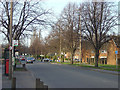
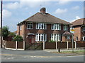
Queens Road, Beeston
A very standard tween-wars suburban main road providing a straightforward way past the commercial centre of Beeston.
Image: © Alan Murray-Rust
Taken: 27 Jan 2008
0.08 miles