IMAGES TAKEN NEAR TO
Manton Crescent, NOTTINGHAM, NG9 2GE
Introduction
This page details the photographs taken nearby to Manton Crescent, NG9 2GE by members of the Geograph project.
The Geograph project started in 2005 with the aim of publishing, organising and preserving representative images for every square kilometre of Great Britain, Ireland and the Isle of Man.

There are currently over 7.5m images from over14,400 individuals and you can help contribute to the project by visiting https://www.geograph.org.uk
Image Map
Images are licensed for reuse under creativecommons.org/licenses/by-sa/2.0
Notes
- Clicking on the map will re-center to the selected point.
- The higher the marker number, the further away the image location is from the centre of the postcode.
Image Listing (51 Images Found)
Images are licensed for reuse under creativecommons.org/licenses/by-sa/2.0
Image
Details
Distance
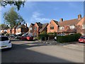
1
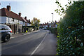
Manton Crescent
This is a very narrow crescent and is not helped by quite a number of white vans parked half on the pavement. I suppose for traffic flow that is better but cannot be good for pedestrians.
Image: © Malcolm Neal
Taken: 25 Nov 2021
0.01 miles
2
Manton Crescent
Part of the Lenton Abbey estate created in the late 1930s.
Image: © Alan Murray-Rust
Taken: 4 Apr 2014
0.02 miles
3
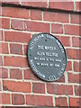
Plaque to Alan Sillitoe
Remembering one of Nottingham's favourite authors probably best known for debut novel "Saturday Night and Sunday Morning" and short story "The Loneliness of the Long Distance Runner" both made into successful films.
Image: © El Loco
Taken: 7 Apr 2021
0.02 miles
4
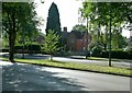
Woodside Road at Manton Crescent
In September sunshine.
Image: © Alan Murray-Rust
Taken: 18 Sep 2016
0.06 miles
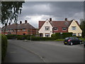
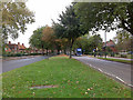
5
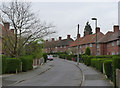
Boundary Road, Beeston
Houses on Boundary Road.
Image: © Andrew Abbott
Taken: 24 Apr 2020
0.06 miles
6
Houses on Boundary Road, Lenton Abbey estate
This varied collection of 1930s council houses are just outside the Nottingham city boundary, hence the name of the road. On the right, partly obscured by parked cars, is one of the many small greens dotted around the estate.
Image: © Richard Vince
Taken: 11 Jun 2013
0.06 miles
7
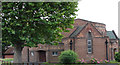
United Reformed Church, Beeston
Viewed from Boundary Road.
Image: © Oxymoron
Taken: 5 Aug 2008
0.09 miles
8
Boundary Road, Beeston
The Beeston United Reformed Church sits on the junction of Boundary Road and Wedsor Avenue. The boundary between The City of Nottingham and (what is now) The Borough of Broxtowe runs next to this road (both sides are in Broxtowe).
Wensor Avenue to the right is bisected by the boundary, which is subject to no sign or change in architecture.
Image: © David Lally
Taken: 30 Jan 2008
0.10 miles
9
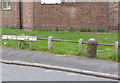
Boundary marker, Wensor Avenue
One of a pair of markers either side of the road, see also http://www.geograph.org.uk/photo/3920782
Image: © Alan Murray-Rust
Taken: 4 Apr 2014
0.11 miles
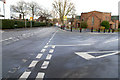
10
Woodside Road, Lenton Abbey
Looking towards the junction with Derby Road (A52).
Image: © David Lally
Taken: 2 Oct 2009
0.11 miles