IMAGES TAKEN NEAR TO
Imperial Road, NOTTINGHAM, NG9 1FN
Introduction
This page details the photographs taken nearby to Imperial Road, NG9 1FN by members of the Geograph project.
The Geograph project started in 2005 with the aim of publishing, organising and preserving representative images for every square kilometre of Great Britain, Ireland and the Isle of Man.

There are currently over 7.5m images from over14,400 individuals and you can help contribute to the project by visiting https://www.geograph.org.uk
Image Map
Images are licensed for reuse under creativecommons.org/licenses/by-sa/2.0
Notes
- Clicking on the map will re-center to the selected point.
- The higher the marker number, the further away the image location is from the centre of the postcode.
Image Listing (800 Images Found)
Images are licensed for reuse under creativecommons.org/licenses/by-sa/2.0
Image
Details
Distance
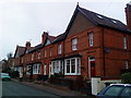
1
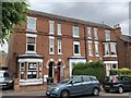
52-56 Imperial Road, Beeston
A terrace of 3 houses by architect John Bowley 1910.
Image: © Andrew Abbott
Taken: 8 Jun 2020
0.01 miles
2
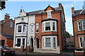
44-46 Imperial Road, Beeston
Semi-detached houses.
Image: © Andrew Abbott
Taken: 24 May 2020
0.02 miles
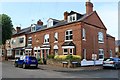
3
56a and 56b Imperial Road, Beeston
Semi-detached houses.
Image: © Andrew Abbott
Taken: 24 May 2020
0.03 miles
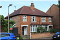
4
32-36 Imperial Road, Beeston
Glenmaye of 1896.
Image: © Andrew Abbott
Taken: 24 May 2020
0.03 miles
5
Harcourt Street, Beeston
A fine terrace of Victorian housing on Harcourt Street, Beeston, mostly retaining wooden windows and doors. Shame about the satellite dishes!
Image: © Andrew Abbott
Taken: 24 Mar 2010
0.04 miles
6
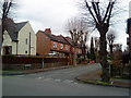
Imperial Avenue, Beeston
Imperial Avenue, Beeston from Imperial Road
Image: © Andrew Abbott
Taken: 22 Mar 2010
0.04 miles
7
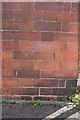
Benchmark on #30 Imperial Road
Ordnance Survey cut mark benchmark described on the Bench Mark Database at http://www.bench-marks.org.uk/bm47830
Image: © Roger Templeman
Taken: 3 Apr 2013
0.04 miles
8
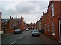
Newton Street, Beeston
Newton Street, Beeston looking east towards Collin Street
Image: © Andrew Abbott
Taken: 22 Mar 2010
0.04 miles
9
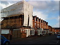
Collington Street, Beeston
The house under scaffolding suffered a fire on 30 January 2010. The residents been growing cannabis in the roof space, and it is thought that the equipment used to propagate the plants caused the fire. The roof collapsed.
Image: © Andrew Abbott
Taken: 26 Mar 2010
0.05 miles
10
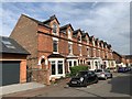
5-17 Collington Street
A row of 7 victorian terraced houses on the Imperial Park Estate.
Image: © Andrew Abbott
Taken: 4 Aug 2019
0.05 miles