IMAGES TAKEN NEAR TO
Morris Road, NOTTINGHAM, NG8 6NE
Introduction
This page details the photographs taken nearby to Morris Road, NG8 6NE by members of the Geograph project.
The Geograph project started in 2005 with the aim of publishing, organising and preserving representative images for every square kilometre of Great Britain, Ireland and the Isle of Man.

There are currently over 7.5m images from over14,400 individuals and you can help contribute to the project by visiting https://www.geograph.org.uk
Image Map
Images are licensed for reuse under creativecommons.org/licenses/by-sa/2.0
Notes
- Clicking on the map will re-center to the selected point.
- The higher the marker number, the further away the image location is from the centre of the postcode.
Image Listing (61 Images Found)
Images are licensed for reuse under creativecommons.org/licenses/by-sa/2.0
Image
Details
Distance
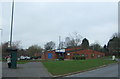
1
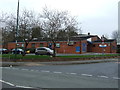
Broxtowe Police Station
A modern replacement for a much smaller unit in the corner of Strelley Recreation Ground, but serving a much wider area of west Nottingham.
Image: © Alan Murray-Rust
Taken: 18 Mar 2014
0.11 miles
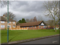
2
Strelley Health Centre
A modern facility on Strelley Road.
Image: © Alan Murray-Rust
Taken: 18 Mar 2014
0.12 miles
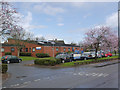
4

Strelley Road at Wigman Road
Part of the B6004, and important orbital link across the northern part of Nottingham.
Image: © Alan Murray-Rust
Taken: 18 Mar 2014
0.13 miles
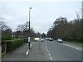
5
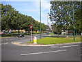
Top of Wigman Road, Bilborough estate
At its north end, the central reservation of Wigman Road widens to form a triangular junction with Strelley Road (left). This was done to enable buses serving the northern end of Bilborough estate to return to the city centre via Wigman Road, a manoeuvre that short workings of Nottingham City Transport service 35 still perform at certain times, particularly on Sundays and during late evenings.
Image: © Richard Vince
Taken: 15 Sep 2012
0.13 miles
8
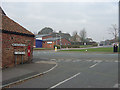
St Martin's Road, Bilborough
This is its junction with Strelley Road, once the old road to Strelley Village, but now a main road through modern housing developments. The cast iron signs indicate that this road is older than the general urban development in this area. The building on the left is called Forge Cottage.
Image: © Alan Murray-Rust
Taken: 4 Nov 2007
0.15 miles
9
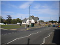
Strelley Road, Strelley estate
Seen at its triangular junction with Moor Road (left), with The Rose pub on the east side of the junction.
Image: © Richard Vince
Taken: 15 Sep 2012
0.15 miles
10

The Rose, Strelley Road
A typical large public house built as part of the post-war development of housing in this area.
Image: © Alan Murray-Rust
Taken: 4 Nov 2007
0.16 miles