IMAGES TAKEN NEAR TO
Norbreck Close, NOTTINGHAM, NG8 6EE
Introduction
This page details the photographs taken nearby to Norbreck Close, NG8 6EE by members of the Geograph project.
The Geograph project started in 2005 with the aim of publishing, organising and preserving representative images for every square kilometre of Great Britain, Ireland and the Isle of Man.

There are currently over 7.5m images from over14,400 individuals and you can help contribute to the project by visiting https://www.geograph.org.uk
Image Map
Images are licensed for reuse under creativecommons.org/licenses/by-sa/2.0
Notes
- Clicking on the map will re-center to the selected point.
- The higher the marker number, the further away the image location is from the centre of the postcode.
Image Listing (10 Images Found)
Images are licensed for reuse under creativecommons.org/licenses/by-sa/2.0
Image
Details
Distance
2
House For Sale, Tilbury Rise, Cinderhill
All boarded up in the winter sun.
Image: © Oxymoron
Taken: 18 Nov 2008
0.14 miles
3
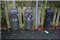
Valve and hydrant markers
At the junction of Bells Lane and Dulverton Vale.
Image: © David Lally
Taken: 8 Feb 2010
0.15 miles
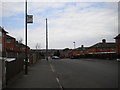
4
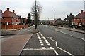
Bell's Lane
Looking north from the junction with Dulverton Vale.
Image: © David Lally
Taken: 8 Feb 2010
0.16 miles
5
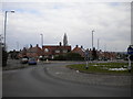
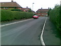
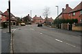
Roundabout at the south end of Bells Lane estate
Bells Lane estate is one of the earlier Nottingham council estates, dating from the 1930s. This roundabout marks the southern edge of the estate, where Bells Lane itself (along which the two cars are heading on the left) diverges from Broxtowe Lane (right). Rosslyn Drive, part of the even older Aspley estate, joins the roundabout out of view to the right.
Image: © Richard Vince
Taken: 28 Mar 2013
0.18 miles
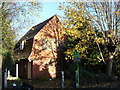
7
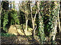
Quarry Holes Plantation Nature Reserve
Entrance off Tilbury Rise.
Image: © Oxymoron
Taken: 18 Nov 2008
0.19 miles
8
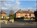
Welstead Avenue from Browtowe Lane
This is the entrance to the Aspley Estate from Broxtowe Lane. The Bulwell Stone garden walls are a relatively unusual feature for interwar council housing.
Image: © SK53
Taken: 1 May 2013
0.21 miles
9
Amesbury Circus
Like most of the council estates to the west and north of Nottingham the Cinderhill estate has at its heart a circular road often there is a school in the centre.
Amesbury Circus is perhaps the largest, with a diameter of about 300 metres.
Image: © David Lally
Taken: 8 Feb 2010
0.22 miles
10
East end of Eltham Drive, Bells Lane estate
Image: © Richard Vince
Taken: 28 Mar 2013
0.25 miles