IMAGES TAKEN NEAR TO
Eltham Close, NOTTINGHAM, NG8 6BS
Introduction
This page details the photographs taken nearby to Eltham Close, NG8 6BS by members of the Geograph project.
The Geograph project started in 2005 with the aim of publishing, organising and preserving representative images for every square kilometre of Great Britain, Ireland and the Isle of Man.

There are currently over 7.5m images from over14,400 individuals and you can help contribute to the project by visiting https://www.geograph.org.uk
Image Map
Images are licensed for reuse under creativecommons.org/licenses/by-sa/2.0
Notes
- Clicking on the map will re-center to the selected point.
- The higher the marker number, the further away the image location is from the centre of the postcode.
Image Listing (10 Images Found)
Images are licensed for reuse under creativecommons.org/licenses/by-sa/2.0
Image
Details
Distance
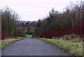
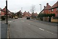
1
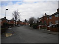
West end of Eltham Drive, Bells Lane estate
As it passes the end of Eltham Close (left), Eltham Drive begins to climb and bend quite sharply to reach Amesbury Circus. Bells Lane estate was built in the 1930s; while the houses are built of the rich orange red brick so characteristic of Nottingham council houses of the period, those here are far more conservatively styled than many on the neighbouring (and slightly older) Aspley estate.
Image: © Richard Vince
Taken: 28 Mar 2013
0.03 miles
2
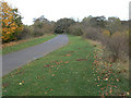
The path into Broxtowe Country Park
The path follows the line of the old colliery railway to Broxtowe Colliery; this was based on some of the oldest colliery tramways in the area.
Image: © Alan Murray-Rust
Taken: 25 Oct 2009
0.04 miles
3
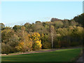
Broxtowe Wood
This forms the basis for Broxtowe Country Park, much of which is on old colliery lands.
Image: © Alan Murray-Rust
Taken: 25 Oct 2009
0.09 miles
4
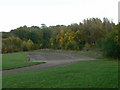
Car Park at Broxtowe Country Park
It's not clear whether this car park was ever used. Certainly the only access today is gated off for vehicles, and as it is largely single track it would have been very inconvenient.
Image: © Alan Murray-Rust
Taken: 25 Oct 2009
0.11 miles
5
Access road, Broxtowe country park
Looking NE over Nuthall.
Image: © Lynne Kirton
Taken: 1 Jan 2006
0.14 miles
6
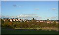
Temple Nuthall estate
Seen from Broxtowe Country Park. Different stages of construction can be clearly seen in this view, with the right hand rows of houses being later than those to the left.
Image: © Alan Murray-Rust
Taken: 25 Oct 2009
0.17 miles
7
Assarts Road, Nuthall
The top end of the Temple Nuthall development, dating from the early 1970s.
Image: © Alan Murray-Rust
Taken: 25 Oct 2009
0.21 miles
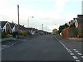
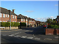
8
East end of Eltham Drive, Bells Lane estate
Image: © Richard Vince
Taken: 28 Mar 2013
0.22 miles
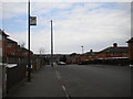
9
Amesbury Circus
Like most of the council estates to the west and north of Nottingham the Cinderhill estate has at its heart a circular road often there is a school in the centre.
Amesbury Circus is perhaps the largest, with a diameter of about 300 metres.
Image: © David Lally
Taken: 8 Feb 2010
0.22 miles
10
Cedarlands Crescent
Although this is the nearest part of the Temple Nuthall development to Nottingham, it was in fact developed later than the area a bit further west, as can be seen by comparing the architecture http://www.geograph.org.uk/photo/1556640 .
Image: © Alan Murray-Rust
Taken: 25 Oct 2009
0.25 miles