IMAGES TAKEN NEAR TO
Nuthall Road, NOTTINGHAM, NG8 6AZ
Introduction
This page details the photographs taken nearby to Nuthall Road, NG8 6AZ by members of the Geograph project.
The Geograph project started in 2005 with the aim of publishing, organising and preserving representative images for every square kilometre of Great Britain, Ireland and the Isle of Man.

There are currently over 7.5m images from over14,400 individuals and you can help contribute to the project by visiting https://www.geograph.org.uk
Image Map
Images are licensed for reuse under creativecommons.org/licenses/by-sa/2.0
Notes
- Clicking on the map will re-center to the selected point.
- The higher the marker number, the further away the image location is from the centre of the postcode.
Image Listing (45 Images Found)
Images are licensed for reuse under creativecommons.org/licenses/by-sa/2.0
Image
Details
Distance
1
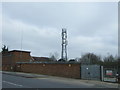
Communications mast, Cinderhill
View from Cinderhill Road.
Image: © JThomas
Taken: 27 Mar 2017
0.13 miles

3
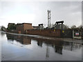
Cinderhill Road substation
The wet road surface makes for a more interesting picture than otherwise.
Image: © Alan Murray-Rust
Taken: 18 Mar 2014
0.13 miles
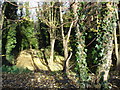
4
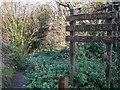
Quarry Holes Plantation Nature Reserve
Entrance off Tilbury Rise.
Image: © Oxymoron
Taken: 18 Nov 2008
0.14 miles
6
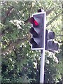
UK Red Toucan Crossing Traffic Light Signal
UK Red Toucan Crossing Traffic Light Signal coming off the A610, Bypass Roundabout at Nottingham Nottinghamshire.
Image: © gary
Taken: 15 Jun 2015
0.15 miles
8
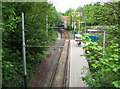
Cinderhill Tram Stop - 1
The Highbury Vale to Phoenix Park branch of the Nottingham tram system is built on the formation of the Midland Railway Babbington (Cinderhill) Colliery Branch, which ran from a junction with the Midland's Nottingham to Mansfield and Worksop line where the Highbury Vale tram stop now is. The Midland line ran parallel to (and in the shadow of) the Great Northern Derbyshire Extension line to Derby, which ran on tall embankments and viaducts - now completely gone - between Cinderhill and Basford North. This view is taken from the Midland Railway bridge carrying Bagnall Road, looking across the tram stop towards Great Northern Bridge No 3, which carried the Cinderhill to Bulwell road over the lines leading to the colliery sidings. To the right of here, where there are now steps and a zig-zag pedestrian ramp, there was once a railway junction where the Great Northern Babbington Colliery line joined the Midland. The GNR cutting has been filled in, but the parapets of GNR Bridge No 2, on Bagnall Road, survive.
Image: © John Sutton
Taken: 19 May 2010
0.17 miles
9
Tram line towards Phoenix Road Park and Ride
Looking west from the bridge on Cinderhill Road.
Image: © JThomas
Taken: 27 Mar 2017
0.18 miles
10
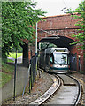
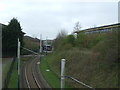
A Clifton-bound tram approaching Cinderhill
The Highbury Vale to Phoenix Park branch of the Nottingham tram system is built on the formation of the Midland Railway Babbington (Cinderhill) Colliery Branch, which ran from a junction with the Midland's Nottingham to Mansfield and Worksop line where the Highbury Vale tram stop now is. The Midland line ran parallel to (and in the shadow of) the Great Northern Derbyshire Extension line to Derby, which ran on tall embankments and viaducts - now completely gone - between Cinderhill and Basford North. This is Great Northern Bridge No 3 carrying Cinderhill Road. Behind and to the right of the camera, where there are now steps and a zig-zag pedestrian ramp, there was once a junction where the GNR Babbington Colliery branch joined the Midland. The GNR cutting has been filled in, but the parapets of its Bridge No 2, on Bagnall Road, survive.
Image: © John Sutton
Taken: 11 Jun 2016
0.18 miles