IMAGES TAKEN NEAR TO
Colliers Way, NOTTINGHAM, NG8 6AT
Introduction
This page details the photographs taken nearby to Colliers Way, NG8 6AT by members of the Geograph project.
The Geograph project started in 2005 with the aim of publishing, organising and preserving representative images for every square kilometre of Great Britain, Ireland and the Isle of Man.

There are currently over 7.5m images from over14,400 individuals and you can help contribute to the project by visiting https://www.geograph.org.uk
Image Map
Images are licensed for reuse under creativecommons.org/licenses/by-sa/2.0
Notes
- Clicking on the map will re-center to the selected point.
- The higher the marker number, the further away the image location is from the centre of the postcode.
Image Listing (62 Images Found)
Images are licensed for reuse under creativecommons.org/licenses/by-sa/2.0
Image
Details
Distance
1
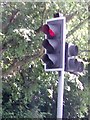
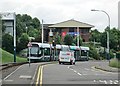
UK Red Toucan Crossing Traffic Light Signal
UK Red Toucan Crossing Traffic Light Signal coming off the A610, Bypass Roundabout at Nottingham Nottinghamshire.
Image: © gary
Taken: 15 Jun 2015
0.02 miles
2
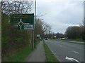
A610 approaching Cinderhill Roundabout
Looking east.
Image: © JThomas
Taken: 27 Mar 2017
0.06 miles

4
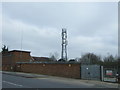
Communications mast, Cinderhill
View from Cinderhill Road.
Image: © JThomas
Taken: 27 Mar 2017
0.09 miles
5
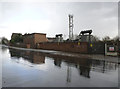
Cinderhill Road substation
The wet road surface makes for a more interesting picture than otherwise.
Image: © Alan Murray-Rust
Taken: 18 Mar 2014
0.10 miles
6

A tram leaving Phoenix Park
Bound for the city centre and the Station Street terminus on a grey summer morning.
Image: © John Sutton
Taken: 24 Jun 2013
0.11 miles
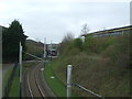
7
A tram on the way to Cinderhill
The tram, bound for the city centre and the Station Street terminus, has just left Phoenix Park and is dropping down to the Cinderhill stop.
Image: © John Sutton
Taken: 24 Jun 2013
0.11 miles
8
Phoenix Park tram terminus
The start of the tram line towards Nottingham city centre.
Image: © Andrew Hill
Taken: 6 Jun 2014
0.13 miles
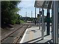
9
Tram line towards Phoenix Road Park and Ride
Looking west from the bridge on Cinderhill Road.
Image: © JThomas
Taken: 27 Mar 2017
0.13 miles
10
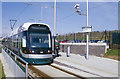
Phoenix Park tram terminus
The Nottingham Express Transit system had been open just over a year when this photograph was taken in 2005. At that time trams only ran between Station Street and two outer termini at Hucknall and here at Phoenix Park, which offered park and ride facilities. The Phoenix Park terminus was built on the site of Cinderhill Colliery, which closed in 1986, and the tramway branch follows the route of the railway that served the colliery.
Image: © Stephen McKay
Taken: Unknown
0.13 miles