IMAGES TAKEN NEAR TO
Nuthall Road, NOTTINGHAM, NG8 5DW
Introduction
This page details the photographs taken nearby to Nuthall Road, NG8 5DW by members of the Geograph project.
The Geograph project started in 2005 with the aim of publishing, organising and preserving representative images for every square kilometre of Great Britain, Ireland and the Isle of Man.

There are currently over 7.5m images from over14,400 individuals and you can help contribute to the project by visiting https://www.geograph.org.uk
Image Map
Images are licensed for reuse under creativecommons.org/licenses/by-sa/2.0
Notes
- Clicking on the map will re-center to the selected point.
- The higher the marker number, the further away the image location is from the centre of the postcode.
Image Listing (21 Images Found)
Images are licensed for reuse under creativecommons.org/licenses/by-sa/2.0
Image
Details
Distance
2
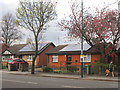
Inter-war terrace with solar panels, Nuthall Road
This 4 house terrace with small porches for the central houses was probably the commonest type of the council housing built by Nottingham Borough Council between the wars. A few were also completed after WWII on the Bestwood Estate. This one on the North side of Nuthall Road is part of the Whitemoor Estate, and nicely shows the solar panels now found on around 4,500 houses owned by Nottingham City Homes, the successor organisation to the borough's housing department.
Image: © SK53
Taken: 1 May 2013
0.10 miles
3
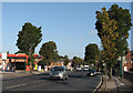
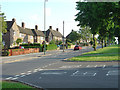
Nuthall Road
Before nine on a bright September morning the majority of traffic is coming in to the city. Newcastle Colliery (1853-1928) and later Newcastle Landsale Wharf stood to the left, taking their name (as did the nearby pub) from the landowner, The Duke of Newcastle. This area was developed in the 1930s, at the same time as Western Boulevard.
Image: © John Sutton
Taken: 13 Sep 2011
0.12 miles

5
541 Dover Inverness 749
Sustrans millennium milepost at Melbourne Road, Basford, Nottingham. The reverse view, generally not posted in Geograph, can be seen in Image
Image: © Alan Murray-Rust
Taken: 4 Jun 2008
0.12 miles
6
Melbourne Road from Nuthall Road
Part of the large Aspley Estate development from the tween wars period
Image: © Alan Murray-Rust
Taken: 4 Jun 2008
0.12 miles
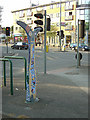
7
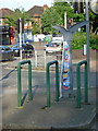
Sustrans milepost
This one stands in the central reservation of Melbourne Road at the junction of Nuthall Road. Provision has been made to park your cycle while looking at it!
Image: © Alan Murray-Rust
Taken: 4 Jun 2008
0.12 miles
8
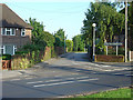
The entrance to Melbourne Park Medical centre
The reason that there is a gap between the houses is that this is the alignment of a former colliery railway that ran parallel to Nuthall Road. It continued to serve a landsale wharf into the 1960s. It crossed Melbourne Road by a level crossing.
Image: © Alan Murray-Rust
Taken: 4 Jun 2008
0.13 miles
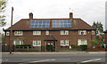
9
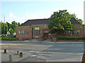
Aspley Library
Nottingham is well provided with branch libraries of various ages. Aspley Library was opened in 1937 to serve the new Aspley estate which lay behind it. It is in a restrained Art Deco style.
Image: © Alan Murray-Rust
Taken: 4 Jun 2008
0.13 miles
10
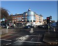
Junction of Melbourne Road with Nuthall road (A610)
With Sainsbury's at the corner. The busy A610 is the main route from north Nottingham to the M1.
Image: © Tim Heaton
Taken: 11 Nov 2012
0.14 miles