IMAGES TAKEN NEAR TO
Whitemoor Court Industrial Estate, Whitemoor Court, NOTTINGHAM, NG8 5BY
Introduction
This page details the photographs taken nearby to Whitemoor Court Industrial Estate, Whitemoor Court, NG8 5BY by members of the Geograph project.
The Geograph project started in 2005 with the aim of publishing, organising and preserving representative images for every square kilometre of Great Britain, Ireland and the Isle of Man.

There are currently over 7.5m images from over14,400 individuals and you can help contribute to the project by visiting https://www.geograph.org.uk
Image Map
Images are licensed for reuse under creativecommons.org/licenses/by-sa/2.0
Notes
- Clicking on the map will re-center to the selected point.
- The higher the marker number, the further away the image location is from the centre of the postcode.
Image Listing (124 Images Found)
Images are licensed for reuse under creativecommons.org/licenses/by-sa/2.0
Image
Details
Distance
2
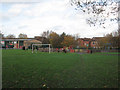
Play Area next to the railway, between Cyril Avenue and Wistow Close
This little green space was once a much larger sports field, used in the 1950s for football by Berridge Road Junior School, and probably others. We walked in a crocodile along Alfreton Road, over the footbridge over the railway at Bobbers Mill and along Nuthall Road. Much of that field has now been taken up by the Whitemoor Court Industrial Estate and the tannery backing on to Albert Avenue is also long gone. There is still a view across the railway to Gerard's Soap Works, now derelict.
Image: © John Sutton
Taken: 20 Nov 2009
0.05 miles
3
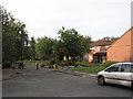
Albert Avenue on royal wedding day
Quite early on the bank-holiday morning there was only limited evidence of any wedding-fever to come. The newer houses on Cyril Avenue are in the background.
Image: © John Sutton
Taken: 29 Apr 2011
0.06 miles
5
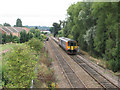
Looking towards Bobbers Mill Bridge
A northbound train passes the newer houses of Plantation Side, built on what was once industrial land
Image: © John Sutton
Taken: 12 Aug 2009
0.07 miles
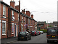
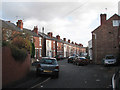
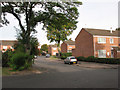
6

Bobbers Mill: Cyril Avenue
The newish houses on the east side of Cyril Avenue, backing on to the railway, are only just in SK5541.
Image: © John Sutton
Taken: 20 Nov 2009
0.08 miles
8
Orchard Close: ready for the royal wedding
Early on the bank-holiday morning the bunting was out but the revellers weren't.
Image: © John Sutton
Taken: 29 Apr 2011
0.08 miles
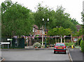
10
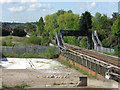
Footbridge over the Mansfield line
This bridge, seen from Wilkinson Street, connects Gauntley Street and Wistow Close. Bobbers Mill is in the distance and a cleared part of the Gerard's Soap Works site (latterly Cussons) in the foreground. The grey security fence at the bottom of the right-hand flight of steps marks the site of the former foot crossing; it was from there that I took my 1967 picture of Gerard's http://www.geograph.org.uk/photo/1537380.
Image: © John Sutton
Taken: 11 May 2010
0.10 miles