IMAGES TAKEN NEAR TO
Nuthall Road, NOTTINGHAM, NG8 5AF
Introduction
This page details the photographs taken nearby to Nuthall Road, NG8 5AF by members of the Geograph project.
The Geograph project started in 2005 with the aim of publishing, organising and preserving representative images for every square kilometre of Great Britain, Ireland and the Isle of Man.

There are currently over 7.5m images from over14,400 individuals and you can help contribute to the project by visiting https://www.geograph.org.uk
Image Map
Images are licensed for reuse under creativecommons.org/licenses/by-sa/2.0
Notes
- Clicking on the map will re-center to the selected point.
- The higher the marker number, the further away the image location is from the centre of the postcode.
Image Listing (128 Images Found)
Images are licensed for reuse under creativecommons.org/licenses/by-sa/2.0
Image
Details
Distance
1
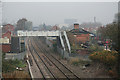
The Leen Valley Railway at Bobbers Mill looking north
This is the site of Bobbers Mill level crossing, which was replaced by the bridge from which this picture was taken.
Image: © Alan Murray-Rust
Taken: 4 Nov 2007
0.03 miles
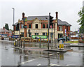
3
Bobbers Mill railway footbridge
There was once a level crossing here, where the old Alfreton Road crossed the Nottingham-Mansfield-Worksop railway line. It was superseded when Bobbers Mill Bridge was built in the 1930s. The plumbing business on the left occupies shops built at the same time as the now-closed Wheatsheaf pub (offstage left).
Image: © John Sutton
Taken: 29 Apr 2014
0.03 miles
4
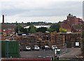
Pile of pallets
This zoom view from Bobbers Mill Bridge shows DTN Pallets' yard, the newish houses on Meadow Brown Road and, in the distance, the former Shipstone's Star Brewery in New Basford and, on the left, the chimney which is all that remains of Gerard's Soap Works, demolished in April 2011.
Image: © John Sutton
Taken: 21 Jun 2011
0.03 miles
5
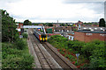
Train approaching Bobbers Mill Bridge
A train from Worksop and Mansfield to Nottingham passes under the footbridge at Bobbers Mill, where there was once also a level crossing on the old Alfreton Road, superseded when Bobbers Mill Bridge, from which the photograph was taken, was built in the 1930s. Alan Murray-Rust's Image] shows the ruinous former crossing-keeper's house (to the right of the footbridge) with more roof, and was taken on a day when one of the Basford gasholders was full. Gerard's Soap Works chimney is in the centre of the picture; the factory was flattened in April 2011. The former Shipstone's Brewery is in the distance on the right.
Image: © John Sutton
Taken: 21 Jun 2011
0.04 miles
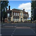
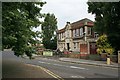
7
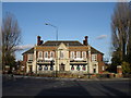
Once The Wheatsheaf
Now, alas, a purveyor of junk food.
Earlier views:
Mick Garratt’s Image] (2007)
David Lally’s Image] (2015)
(Before the War, as a young police constable, my father apprehended a commercial traveller for being drunk and disorderly outside this pub. The headline on a cutting from the local paper in dad's scrapbook reads "Nottingham beer so strong says Oxford man".)
Image: © John Sutton
Taken: 29 Jun 2017
0.04 miles
8
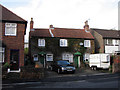
Bobbers Mill: cottages on Cyril Avenue
This is one of the few buildings in Bobbers Mill dating from before the late 19th century, when the area changed from a village to an industrial suburb.
Image: © John Sutton
Taken: 20 Nov 2009
0.04 miles
10
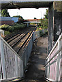
Bobbers Mill's bridges
A view of Bobbers Mill Bridge (built in the 1930s) from the footbridge which links the truncated Alfreton and Nuthall Roads. Before Bobbers Mill Bridge was built, there was a level crossing here.
Image: © John Sutton
Taken: 13 Sep 2012
0.05 miles