IMAGES TAKEN NEAR TO
Monkton Drive, NOTTINGHAM, NG8 4ES
Introduction
This page details the photographs taken nearby to Monkton Drive, NG8 4ES by members of the Geograph project.
The Geograph project started in 2005 with the aim of publishing, organising and preserving representative images for every square kilometre of Great Britain, Ireland and the Isle of Man.

There are currently over 7.5m images from over14,400 individuals and you can help contribute to the project by visiting https://www.geograph.org.uk
Image Map
Images are licensed for reuse under creativecommons.org/licenses/by-sa/2.0
Notes
- Clicking on the map will re-center to the selected point.
- The higher the marker number, the further away the image location is from the centre of the postcode.
Image Listing (4 Images Found)
Images are licensed for reuse under creativecommons.org/licenses/by-sa/2.0
Image
Details
Distance
1

Wigman Road: BISF houses
These steel-framed prefabricated council houses are some of the many erected in Bilborough in the years after the Second World War. For the history of BISF houses, see http://en.wikipedia.org/wiki/BISF_house .
Image: © John Sutton
Taken: 13 May 2014
0.06 miles
2
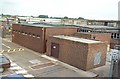
Primary Substation, Bilborough
A primary substation that supplies power to a large area of Nottingham.
Image: © Garth Newton
Taken: 9 Aug 2000
0.21 miles
4
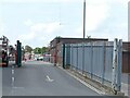
Primary Substation, Bilborough
Taken on an attempt to recreate this 'First' for the square https://www.geograph.org.uk/photo/18959 . Not replicable without access to the upper floor of the Nottingham City Council depot at Woolsthorpe Close!
Image: © Alan Murray-Rust
Taken: 3 Aug 2021
0.24 miles