IMAGES TAKEN NEAR TO
Walesby Crescent, NOTTINGHAM, NG8 3NL
Introduction
This page details the photographs taken nearby to Walesby Crescent, NG8 3NL by members of the Geograph project.
The Geograph project started in 2005 with the aim of publishing, organising and preserving representative images for every square kilometre of Great Britain, Ireland and the Isle of Man.

There are currently over 7.5m images from over14,400 individuals and you can help contribute to the project by visiting https://www.geograph.org.uk
Image Map
Images are licensed for reuse under creativecommons.org/licenses/by-sa/2.0
Notes
- Clicking on the map will re-center to the selected point.
- The higher the marker number, the further away the image location is from the centre of the postcode.
Image Listing (29 Images Found)
Images are licensed for reuse under creativecommons.org/licenses/by-sa/2.0
Image
Details
Distance
1
Government Buildings
located on Chalfont Drive in Nottingham
Image: © Tom Courtney
Taken: 9 Sep 2005
0.07 miles
2
"Government Buildings"
Recreating this 'First' for the square https://www.geograph.org.uk/photo/51212 . The Government Buildings were vacated around 2010 and have been replaced by new housing.
Image: © Alan Murray-Rust
Taken: 3 Aug 2021
0.08 miles
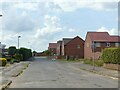
4
Trentham Gardens, Aspley
Apparently named after the country estate on the fringe of the Potteries, this road is part of a suburban development south of the middle section of Aspley Lane.
Image: © Richard Vince
Taken: 1 Feb 2013
0.15 miles
6
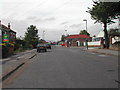
Radford Bridge Road
This is part of the route of National Cycle Route number 6 through Nottingham.
Image: © Oxymoron
Taken: 6 Aug 2008
0.16 miles
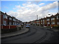
7
Entrance to Government Buildings, Aspley
The entrance to the Chalfont Drive Government Buildings complex from Robin's Wood Road, Aspley. Security is high at this complex, although the site seems only to be used for relatively prosaic government functions; for example, it houses branches of the Driving Standards Agency and the Land Registry.
Image: © Richard Vince
Taken: 1 Feb 2013
0.18 miles
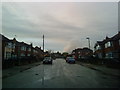
8
On Robins Wood Road
This is the Beechdale Road end of a road which links the Beechdale and Aspley Estates.
Image: © John Sutton
Taken: 13 May 2014
0.18 miles
9
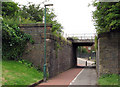
Radford Bridge Road: the north side of the railway bridge
The bridge carries the line from Radford Junction to Trowell Junction on the Erewash Valley Line, which was built in 1875 to enable trains to and from the north to avoid the bottlenecks at Trent and Toton. It also served Wollaton Colliery (1873-1965).
The substantial blue-brick abutments show that the bridge was once much wider. It once carried three more tracks, known as Babbington Sidings. From the 19th century until the building of Western Boulevard and the houses either side of it in the 1930s, a railway linking Babbington (Cinderhill) Colliery and the Nottingham Canal at a wharf immediately south of Wollaton Road crossed the Radford-Trowell main line at right angles on the level just east of where Western Boulevard bridge now stands. Babbington Sidings were connected to that line, but the connexion was out of use by the time the 1914-16 OS map was surveyed.
For other vestiges of the Babbington Colliery line, see Image], Image], Image], Image], Image] and Image For a view of the other side of the bridge and a little about Radford Woodhouse, see Image
Image: © John Sutton
Taken: 12 Jul 2011
0.18 miles
10
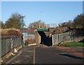
Cycle Route 6 passing beneath the Nottingham to Sheffield railway line
Image: © Tim Heaton
Taken: 11 Nov 2012
0.18 miles