IMAGES TAKEN NEAR TO
Manville Close, NOTTINGHAM, NG8 3LP
Introduction
This page details the photographs taken nearby to Manville Close, NG8 3LP by members of the Geograph project.
The Geograph project started in 2005 with the aim of publishing, organising and preserving representative images for every square kilometre of Great Britain, Ireland and the Isle of Man.

There are currently over 7.5m images from over14,400 individuals and you can help contribute to the project by visiting https://www.geograph.org.uk
Image Map
Images are licensed for reuse under creativecommons.org/licenses/by-sa/2.0
Notes
- Clicking on the map will re-center to the selected point.
- The higher the marker number, the further away the image location is from the centre of the postcode.
Image Listing (25 Images Found)
Images are licensed for reuse under creativecommons.org/licenses/by-sa/2.0
Image
Details
Distance
1
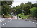
Radford Bridge Road
This is part of the route of National Cycle Route number 6 through Nottingham.
Image: © Oxymoron
Taken: 6 Aug 2008
0.04 miles
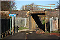
2
Radford Bridge Road: the south side of the railway bridge
The bridge carries the line from Radford Junction to Trowell Junction on the Erewash Valley Line, which was built by the Midland Railway in 1875 to enable trains to and from the north to avoid the bottlenecks at Trent and Toton. It also served Wollaton Colliery (1873-1965). This area was once called Radford Woodhouse, but its three Victorian terraces (to the right), Gate, Vane and Leavers Street, were demolished long ago and replaced more recently by streets named after railway locomotive engineers: Aspinall Court, Lambie Close and Peppercorn Gardens. None of these designers had any connexion with the Midland, so the council officials who chose them were less on-the-ball than when naming streets on former Great Northern Railway land at Sneinton after Gresley and Ivatt.
For a view of the other side of the bridge and more railway history, see Image
Image: © John Sutton
Taken: 12 Jul 2011
0.05 miles
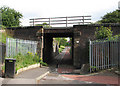
3
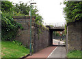
Route 6 underpass
NCN route 6 under a railway line on Radford Bridge Road
Image: © Richard Croft
Taken: 25 Nov 2011
0.05 miles
4
Radford Bridge
Carrying the former Midland Railway over Radford Bridge Road.
Image: © Andrew Abbott
Taken: 23 Aug 2020
0.05 miles
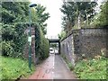
5
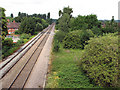
Radford Bridge Road: the north side of the railway bridge
The bridge carries the line from Radford Junction to Trowell Junction on the Erewash Valley Line, which was built in 1875 to enable trains to and from the north to avoid the bottlenecks at Trent and Toton. It also served Wollaton Colliery (1873-1965).
The substantial blue-brick abutments show that the bridge was once much wider. It once carried three more tracks, known as Babbington Sidings. From the 19th century until the building of Western Boulevard and the houses either side of it in the 1930s, a railway linking Babbington (Cinderhill) Colliery and the Nottingham Canal at a wharf immediately south of Wollaton Road crossed the Radford-Trowell main line at right angles on the level just east of where Western Boulevard bridge now stands. Babbington Sidings were connected to that line, but the connexion was out of use by the time the 1914-16 OS map was surveyed.
For other vestiges of the Babbington Colliery line, see Image], Image], Image], Image], Image] and Image For a view of the other side of the bridge and a little about Radford Woodhouse, see Image
Image: © John Sutton
Taken: 12 Jul 2011
0.05 miles
6
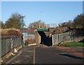
Cycle Route 6 passing beneath the Nottingham to Sheffield railway line
Image: © Tim Heaton
Taken: 11 Nov 2012
0.05 miles
8
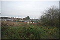
West from Western Boulevard Bridge
This is the line from Radford Junction to Trowell Junction on the Erewash Valley Line, which was built to enable trains to and from the north to avoid the bottlenecks at Trent and Toton. For a view towards here from Woodyard Lane, see Image
The railway formation here, overgrown to the right, is wider than the current double track as from the 19th century until the building of Western Boulevard and the houses either side, it was the site of Babbington Sidings, which ran parallel to the main line almost as far west as Woodyard Lane. The railway serving these sidings linked Babbington (Cinderhill) Colliery and the Nottingham Canal at a wharf immediately south of Wollaton Road and crossed this line on the level east of this bridge - see Image
For other vestiges of the Babbington Colliery line, see Image], Image], Image], Image], and Image]
Image: © John Sutton
Taken: 12 Jul 2011
0.05 miles
9
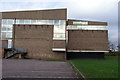
Beechdale Swimming Centre
I'm not sure when this was built, but between 1965 and 1975 is pretty certain I'd say
Image: © David Lally
Taken: 28 Nov 2007
0.10 miles
10
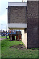
Beechdale Swimming Centre - Strange growth
There are no windows in this strange protuberance, just two air bricks in the wall parallel to the building. I wonder what it looks like from the inside.
Image: © David Lally
Taken: 28 Nov 2007
0.11 miles