IMAGES TAKEN NEAR TO
St. Levan Close, NOTTINGHAM, NG8 3BA
Introduction
This page details the photographs taken nearby to St. Levan Close, NG8 3BA by members of the Geograph project.
The Geograph project started in 2005 with the aim of publishing, organising and preserving representative images for every square kilometre of Great Britain, Ireland and the Isle of Man.

There are currently over 7.5m images from over14,400 individuals and you can help contribute to the project by visiting https://www.geograph.org.uk
Image Map
Images are licensed for reuse under creativecommons.org/licenses/by-sa/2.0
Notes
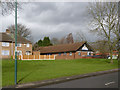
- Clicking on the map will re-center to the selected point.
- The higher the marker number, the further away the image location is from the centre of the postcode.
Image Listing (56 Images Found)
Images are licensed for reuse under creativecommons.org/licenses/by-sa/2.0
Image
Details
Distance
1

Housing near the top of Wigman Road, Bilborough estate
The side road provides access to a block of garages, visible between the houses.
Image: © Richard Vince
Taken: 15 Sep 2012
0.03 miles
2

St Michael's Avenue
Part of a small Radburn-style development built after the main Bilborough estate. Buildings front onto green spaces with pedestrian walkways with vehicle access confined to the rear.
Image: © Alan Murray-Rust
Taken: 18 Mar 2014
0.03 miles
3
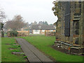
From Bilborough churchyard
The west end of the churchyard looking into part of Bilborough Estate.
Image: © Alan Murray-Rust
Taken: 4 Nov 2007
0.03 miles
4

Bus stop on Wigman Road, Bilborough
Looking north west.
Image: © JThomas
Taken: 27 Mar 2017
0.05 miles
5
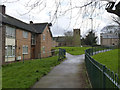
St Michael's Avenue
Part of a small Radburn-style development built after the main Bilborough estate. The medieval church in the background is dedicated to St Martin.
Image: © Alan Murray-Rust
Taken: 18 Mar 2014
0.05 miles
6
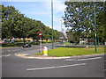
Top of Wigman Road, Bilborough estate
At its north end, the central reservation of Wigman Road widens to form a triangular junction with Strelley Road (left). This was done to enable buses serving the northern end of Bilborough estate to return to the city centre via Wigman Road, a manoeuvre that short workings of Nottingham City Transport service 35 still perform at certain times, particularly on Sundays and during late evenings.
Image: © Richard Vince
Taken: 15 Sep 2012
0.06 miles
7

Strelley Road at Wigman Road
Part of the B6004, and important orbital link across the northern part of Nottingham.
Image: © Alan Murray-Rust
Taken: 18 Mar 2014
0.06 miles
8
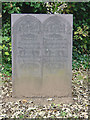
Slate gravestone in Bilborough church yard
The growth of the slate industry in the mid 18th century has given us many fine incised gravestones like this one. At first glance this looks as if it might have been a mechanically produced design, but detailed examination show that there are plenty of variations between the two halves.
Image: © Alan Murray-Rust
Taken: 4 Nov 2007
0.07 miles
9
Broxtowe Police Station
A modern replacement for a much smaller unit in the corner of Strelley Recreation Ground, but serving a much wider area of west Nottingham.
Image: © Alan Murray-Rust
Taken: 18 Mar 2014
0.07 miles
10
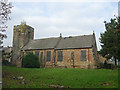
St Martin of Tours, Bilborough
This attractive 14th Century church survives as an oasis in the middle of council housing development.
Image: © Alan Murray-Rust
Taken: 4 Nov 2007
0.08 miles