IMAGES TAKEN NEAR TO
Wroxham Drive, NOTTINGHAM, NG8 2QS
Introduction
This page details the photographs taken nearby to Wroxham Drive, NG8 2QS by members of the Geograph project.
The Geograph project started in 2005 with the aim of publishing, organising and preserving representative images for every square kilometre of Great Britain, Ireland and the Isle of Man.

There are currently over 7.5m images from over14,400 individuals and you can help contribute to the project by visiting https://www.geograph.org.uk
Image Map
Images are licensed for reuse under creativecommons.org/licenses/by-sa/2.0
Notes
- Clicking on the map will re-center to the selected point.
- The higher the marker number, the further away the image location is from the centre of the postcode.
Image Listing (43 Images Found)
Images are licensed for reuse under creativecommons.org/licenses/by-sa/2.0
Image
Details
Distance
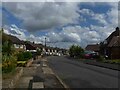
2
Wroxham Drive
Typical 1950s/60s suburban development.
Image: © Alan Murray-Rust
Taken: 6 Sep 2009
0.11 miles
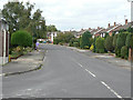
4
Sheraton Drive
The area west of the Park was developed for housing between the wars.
Image: © Alan Murray-Rust
Taken: 19 Oct 2008
0.14 miles
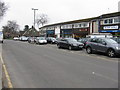
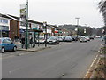
5
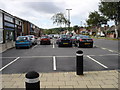
Bramcote Lane Shopping Parade
The shops are situated on both sides of the road, with car parking in front. Unlike many other similar areas this parade still has many proper shops (butchers, bakers, newsagent, post office, hardware store, etc), rather than the ubiquitous banks, estate agents, and betting shops.
Image: © Oxymoron
Taken: 10 Aug 2008
0.15 miles
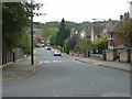
6
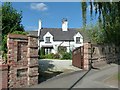
Model Cottage, Bramcote Lane
Until the coming of major housing development in the area, this was the only house between Wollaton village and Bramcote village.
The name derives from its relationship to Model Farm, which was located in a rectangle bounded by Wollaton Vale, Grangewood Road and Edlington Drive.
Image: © Alan Murray-Rust
Taken: 18 Sep 2016
0.15 miles
7
The Hemlock Stone
Former Kinberley's (Hardy Hansons) pub on Wollaton Vale. Seen many makeovers since the Greene King takeover. However this looks just about the same as (by coincidence) exactly one year previous. Image
Image: © David Lally
Taken: 18 Aug 2022
0.16 miles
8
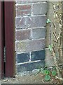
Bench mark, 137 Wollaton Vale
Close up view obtained courtesy of the owners.
Image: © Alan Murray-Rust
Taken: 18 Sep 2016
0.16 miles

10
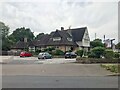
Local shops at Bramcote Hills
On Bramcote Lane.
Image: © M J Richardson
Taken: 3 Mar 2011
0.16 miles