IMAGES TAKEN NEAR TO
Parkside Rise, NOTTINGHAM, NG8 2PA
Introduction
This page details the photographs taken nearby to Parkside Rise, NG8 2PA by members of the Geograph project.
The Geograph project started in 2005 with the aim of publishing, organising and preserving representative images for every square kilometre of Great Britain, Ireland and the Isle of Man.

There are currently over 7.5m images from over14,400 individuals and you can help contribute to the project by visiting https://www.geograph.org.uk
Image Map
Images are licensed for reuse under creativecommons.org/licenses/by-sa/2.0
Notes
- Clicking on the map will re-center to the selected point.
- The higher the marker number, the further away the image location is from the centre of the postcode.
Image Listing (44 Images Found)
Images are licensed for reuse under creativecommons.org/licenses/by-sa/2.0
Image
Details
Distance
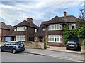
1
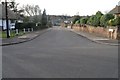
Parkside Rise, Wollaton
This pleasant road runs up from Wollaton Vale to Parkside.
With Bramcote Hills in the distance
Image: © David Lally
Taken: 9 Jan 2008
0.00 miles
2
Parkside Rise, Wollaton Vale
Part of the extensive development of housing to the west of Wollaton Park which took place from the mid 1930s onwards.
Image: © Alan Murray-Rust
Taken: 18 Sep 2016
0.03 miles
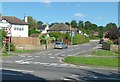
3
Parkside, Wollaton
At the junction with Parkside Rise
Image: © Andrew Abbott
Taken: 19 May 2020
0.04 miles
4
Houses on Wollaton Vale
Mostly from the 1950s.
Image: © Andrew Abbott
Taken: 24 Apr 2020
0.09 miles
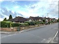
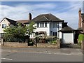
5
61 and 63 Parkside, Wollaton
Detached houses from the 1930s
Image: © Andrew Abbott
Taken: 19 May 2020
0.10 miles
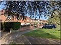
6
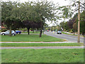
Wollaton Vale
Although not classified this is an important cut through round the west of Nottingham.
Image: © Alan Murray-Rust
Taken: 6 Sep 2009
0.11 miles
8
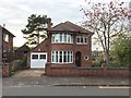
Detached house
Parkside, Wollaton, dating from the early 1950s
Image: © Andrew Abbott
Taken: 13 Nov 2016
0.14 miles
9
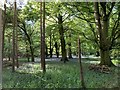
Bluebells in Thompson's Wood
In Wollaton Park
Image: © Andrew Abbott
Taken: 6 May 2020
0.14 miles
10
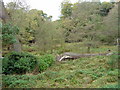
Thompson's Wood
The pool shown on the OS map has become swampland over the years. This part of Wollaton Park is not open to the public to allow the habitat to develop naturally.
Image: © Alan Murray-Rust
Taken: 19 Oct 2008
0.15 miles