IMAGES TAKEN NEAR TO
Wollaton Vale, NOTTINGHAM, NG8 2NR
Introduction
This page details the photographs taken nearby to Wollaton Vale, NG8 2NR by members of the Geograph project.
The Geograph project started in 2005 with the aim of publishing, organising and preserving representative images for every square kilometre of Great Britain, Ireland and the Isle of Man.

There are currently over 7.5m images from over14,400 individuals and you can help contribute to the project by visiting https://www.geograph.org.uk
Image Map
Images are licensed for reuse under creativecommons.org/licenses/by-sa/2.0
Notes
- Clicking on the map will re-center to the selected point.
- The higher the marker number, the further away the image location is from the centre of the postcode.
Image Listing (77 Images Found)
Images are licensed for reuse under creativecommons.org/licenses/by-sa/2.0
Image
Details
Distance
1
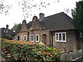
Semi-detached bungalows
Dating from the early 1950s on Wollaton Vale
Image: © Andrew Abbott
Taken: 13 Nov 2016
0.01 miles
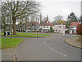
2
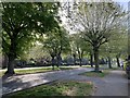
Wollaton Vale
The short section of dual carriageway on Wollaton Vale.
Image: © Andrew Abbott
Taken: 24 Apr 2020
0.02 miles
3
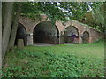
Wollaton Park Lake, the boathouse
This is an eighteenth century structure, but water levels have changed so that there is no longer water inside.
Image: © Alan Murray-Rust
Taken: 19 Oct 2008
0.03 miles
4
The back of the boathouse
This is an eighteenth century structure, but water levels have changed so that there is no longer water inside. Originally the doorways would have provided access to the boats.
Image: © Alan Murray-Rust
Taken: 19 Oct 2008
0.04 miles
5
Boundary stone, Wollaton Park
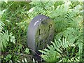
On the dam of the lake. The lettering represents Lenton Parish.
Image: © Alan Murray-Rust
Taken: 3 Aug 2021
0.04 miles
6
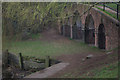
The boathouse, Wollaton Park Lake
This curious boathouse stands at the southern corner of the lake.
Image: © Stephen McKay
Taken: 21 Apr 2013
0.04 miles
7
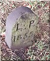
Old Boundary Marker in Wollaton Park, Nottingham
Parish Boundary Marker against a metal fence on the dam of the lake in Wollaton Park, Nottingham. L P stands for Lenton Parish. This stands on the former boundary of Lenton parish (became part of Nottingham parish in 1897) and Wollaton parish (became part of Nottingham parish in 1933). See also https://www.geograph.org.uk/photo/6922300.
Milestone Society National ID: NT_NOT35pb
Image: © N Osmond
Taken: 26 Sep 2022
0.05 miles
8
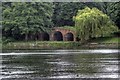
False Bridge, Wollaton Park
Seen from across the southern tip of the lake this was probably a boathouse designed to "enhance the landscape".
Image: © Mick Garratt
Taken: 6 Jul 2008
0.05 miles
9
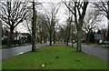
Junction of Parkside and Wollaton Vale
Looking south along Parkside. Substantial town houses along the broad Wollaton Vale, but I'm not sure how the pink house came about as it seems totally out of character.
Image: © Trevor Rickard
Taken: 29 Jan 2011
0.05 miles
10
Wollaton Vale
At its southern end where it meets the A52 at the Priory Roundabout.
It is only a dual carriageway for the first couple of hundred yards. At the left-hand bend visible in the distance (where Parkside branches-off) it becomes two-way-traffic.
Image: © David Lally
Taken: 15 Jan 2009
0.06 miles