IMAGES TAKEN NEAR TO
Glenwood Avenue, NOTTINGHAM, NG8 2GA
Introduction
This page details the photographs taken nearby to Glenwood Avenue, NG8 2GA by members of the Geograph project.
The Geograph project started in 2005 with the aim of publishing, organising and preserving representative images for every square kilometre of Great Britain, Ireland and the Isle of Man.

There are currently over 7.5m images from over14,400 individuals and you can help contribute to the project by visiting https://www.geograph.org.uk
Image Map
Images are licensed for reuse under creativecommons.org/licenses/by-sa/2.0
Notes
- Clicking on the map will re-center to the selected point.
- The higher the marker number, the further away the image location is from the centre of the postcode.
Image Listing (26 Images Found)
Images are licensed for reuse under creativecommons.org/licenses/by-sa/2.0
Image
Details
Distance
1
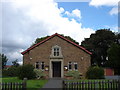
Church of St Thomas More, Glenwood Avenue, Wollaton
This Roman Catholic church was opened in 1956. In 2013 plans were announced to redevelop the site with a larger church and 18 new homes on the corner of Glenwood Avenue and Bramcote Lane.
Image: © Oxymoron
Taken: 12 Aug 2008
0.03 miles
2
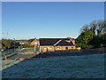
St Thomas church hall, Glenwood Avenue
The church itself Image is just beyond the hall.
Image: © Stephen Craven
Taken: 19 Jan 2020
0.05 miles
3
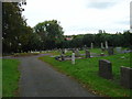
Wollaton Cemetery
The cemetery was opened in 1879 when the graveyard attached to St Leonard's Church, Wollaton became full. It was closed in 1987.
Image: © Alan Murray-Rust
Taken: 19 Oct 2008
0.07 miles
4

Cemetery on Bramcote Lane, Wollaton
Wollaton Cemetery in Bramcote Lane was opened in 1879 when the graveyard attached to St Leonard's Church, Wollaton became full. It was closed in 1987.
Image: © Oxymoron
Taken: 12 Aug 2008
0.08 miles
6

Wollaton filling station
On Wollaton Vale
Image: © Andrew Abbott
Taken: 24 Apr 2020
0.12 miles
7
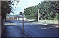
Bramcote Lane, Wollaton
Beyond this point Bramcote Lane drops quite steeply to its junction with Wollaton Vale; Parkside - which runs along the south western edge of Wollaton Park - leads off to the left. Note the Trent bus stop flag mounted rather awkwardly on a concrete post designed to take a traditional small square Midland General flag mounted on top - by 1977, however, Midland General had been absorbed by Trent.
Image: © Stephen McKay
Taken: Unknown
0.12 miles
8
The Hemlock Stone
Recently refurbished, not yet tried it out but certainly looks nice.
Image: © David Lally
Taken: 28 Aug 2008
0.13 miles
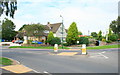
9

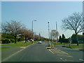
Roundabout on Wollaton Vale
At the junction with Bramcote Lane.
Image: © Stephen Craven
Taken: 19 Jan 2020
0.13 miles
10
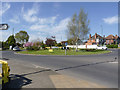
Hemlock Stone roundabout
The unofficial name, taken from the adjacent public house, rather than the rock feature itself.
Image: © Alan Murray-Rust
Taken: 16 Apr 2014
0.13 miles