IMAGES TAKEN NEAR TO
Arleston Drive, NOTTINGHAM, NG8 2FR
Introduction
This page details the photographs taken nearby to Arleston Drive, NG8 2FR by members of the Geograph project.
The Geograph project started in 2005 with the aim of publishing, organising and preserving representative images for every square kilometre of Great Britain, Ireland and the Isle of Man.

There are currently over 7.5m images from over14,400 individuals and you can help contribute to the project by visiting https://www.geograph.org.uk
Image Map
Images are licensed for reuse under creativecommons.org/licenses/by-sa/2.0
Notes
- Clicking on the map will re-center to the selected point.
- The higher the marker number, the further away the image location is from the centre of the postcode.
Image Listing (134 Images Found)
Images are licensed for reuse under creativecommons.org/licenses/by-sa/2.0
Image
Details
Distance
1

Wollaton Cricket Ground
Seen from the pavilion on a Friday morning.
Image: © John Sutton
Taken: 14 Jun 2013
0.10 miles
2
Deer Park
A more recently developed enclave than the surrounding roads, presumably on land that was either a garden or an orchard.
Image: © Alan Murray-Rust
Taken: 19 Oct 2008
0.11 miles
3
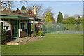
Wollaton Village Tennis Club
Local long-established tennis club with three courts sandwiched between Wollaton Road and the cricket field. The clubhouse, although flimsy in appearance, dates back to the early 1960s.
Image: © Stephen McKay
Taken: 10 Feb 2008
0.12 miles
4
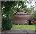
Dovecote, Wollaton, Nottingham
The dovecote, c.1560, is seen here from the closed end of Dovecote Drive (a quiet cul-de-sac). Doves were used to create supplies of food for consumption during winter. The tiles are apparently original and the initials FW can be seen on either side of the building, an indication that it belonged to Sir Francis Willoughby. It seems that its existence was first recorded in 1585 when a new Wollaton Hall was being built. As a museum it is open to the public at certain times during the warmer months and in addition it is the base of the Wollaton Historical and Conservation Society.
Image: © David Hallam-Jones
Taken: 13 Sep 2015
0.12 miles
5
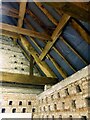
Wollaton Dovecote interior, upper floor
Showing the nesting holes built into the wall and the timber framing of the roof. The nesting holes are L-shaped to provide a partially enclosed nesting space. Listed Grade II.
Image: © Alan Murray-Rust
Taken: 12 Sep 2021
0.13 miles
6
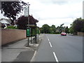
Bus stop and shelter on Russell Drive, Wollaton
Image: © JThomas
Taken: 9 Jul 2016
0.13 miles
7
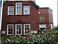
William Wright Memorial Institute, Wollaton
This pleasant old building is now a private nursery, one of three within 200 m of each other in this resolutely middle class area of Nottingham. The plaque above the door reads: "William Wright Memorial Institute, 1900". Perhaps William Wright was a scion of one of the local "big" families, the Wrights of (nearby) Stapleford Hall [http://www.stapleford-notts.co.uk/staplefordhall.htm]?
Image: © Oxymoron
Taken: 12 Jul 2008
0.13 miles
8
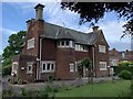
Melrose House, Wollaton
777 Wollaton Road.
Image: © Andrew Abbott
Taken: 19 May 2020
0.13 miles
9
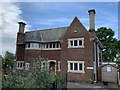
Melrose House, Wollaton
777 Wollaton Road
Image: © Andrew Abbott
Taken: 19 May 2020
0.13 miles
10
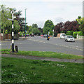
Wollaton: Doctor's Corner
Looking along the A609 Trowell Road in the Ilkeston direction from the junction of Wollaton Road (the original road through the village) and Russell Drive, built to bypass Wollaton in the 1930s.
Image: © John Sutton
Taken: 14 Jun 2013
0.13 miles