IMAGES TAKEN NEAR TO
Western Boulevard, NOTTINGHAM, NG8 1PG
Introduction
This page details the photographs taken nearby to Western Boulevard, NG8 1PG by members of the Geograph project.
The Geograph project started in 2005 with the aim of publishing, organising and preserving representative images for every square kilometre of Great Britain, Ireland and the Isle of Man.

There are currently over 7.5m images from over14,400 individuals and you can help contribute to the project by visiting https://www.geograph.org.uk
Image Map
Images are licensed for reuse under creativecommons.org/licenses/by-sa/2.0
Notes
- Clicking on the map will re-center to the selected point.
- The higher the marker number, the further away the image location is from the centre of the postcode.
Image Listing (102 Images Found)
Images are licensed for reuse under creativecommons.org/licenses/by-sa/2.0
Image
Details
Distance
1
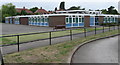
Southwold Primary School, Radford
Southwold Primary School was built in 1968 to serve the local council housing. Many people in the area then worked for Raleigh or Players. Formerly it was known as Wollaton Board School and was located where the University's Jubilee Campus is now sited. The school now serves a rich and diverse community with a range of cultures.
Image: © Sally Holmes
Taken: 1 Aug 2006
0.02 miles
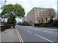
2

Western Boulevard
The Nottingham Ring Road just north of Crown Island
Image: © Alan Murray-Rust
Taken: 19 Oct 2008
0.04 miles
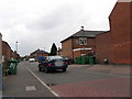
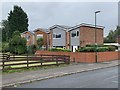
3
Marchwood Close, off Wollaton Road
Typical Nottingham council houses.
Image: © John Sutton
Taken: 20 Nov 2009
0.05 miles
4
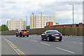
Round Wollaton Road roundabouts
In the background are the two remaining blocks of the old Player's Bonded Warehouse. Demolition began in June 2017. The site will be redeveloped as an extension of Nottingham University's Jubilee Campus. The cars are in the centre lane, so are probably heading for the city up Ilkeston Road.
Image: © John Sutton
Taken: 24 Aug 2017
0.08 miles
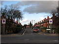
5
Kennington Road, Radford
Kennington Road is part of the catchment area for Southwold Primary School. It is a cul-de-sac, with a railway line running just beyond the furthest most houses.
Image: © Sally Holmes
Taken: 1 Aug 2006
0.08 miles
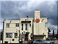
7
Crown Hotel
Art deco pub on the corner of Trowell Road and Western Boulevard. It still retains the former Home Ales name in the stucco.
Image: © Alan Murray-Rust
Taken: 19 Oct 2008
0.08 miles
8
University car park - once a canal wharf
This is part of the Jubilee Campus of Nottingham University, and I really needed a photo permit, the friendly gateman told me. My reason for taking this dull picture on a dull morning, I explained, was that in the distant past this was the site of the canalside part of Babbington Wharf, where coal brought by a single-track railway from Babbington Colliery at Cinderhill was transferred to barges. The other part of Babbington Wharf was a set of sidings and a weighbridge on the other side of Wollaton Road, more or less where the houses and gardens of Marchwood Close are now. The wharf and the canal fell out of use in the first part of the 20th century and the Babbington Colliery Railway was abandoned south of Newcastle Wharf and Melbourne Park when Western Boulevard was built in the 1930s. Old OS maps show all of this clearly.
For other vestiges of the Babbington Colliery line, see Image], Image], Image], Image], Image], Image], Image] and Image
Image: © John Sutton
Taken: 12 Jul 2011
0.09 miles
9
Houses on Radford Bridge Road
Dating from the 1970s and built on an old allotment site.
Image: © Andrew Abbott
Taken: 23 Aug 2020
0.09 miles
10
Nottingham - NG7 (Lenton)
These Imperial Tobacco Company warehouses on Wollaton Road (A609) were originally owned by Players. Although John Player (1839-84) was born in Saffron Walden, Essex he began his career by purchasing a shop on Beastmarket Hill NG1 and selling seeds and fertiliser. Later he started to sell loose tobacco to farmers and very soon his tobacco sales were proving much more lucrative. By 1871 he was registered as a tobacconist and was employing one man and three boys. In 1877, he bought a small tobacco factory at 45, Broadmarsh. By 1939 his third factory on Radford Boulevard had been constructed along with these bonded tobacco warehouses. Until their demolition, 2016-22, the latter had the capacity to store 20,000 tons of tobacco leaf. However, the site, including these buildings, was acquired by the University in 2016 for a 280-room hall of residence.
Image: © David Hallam-Jones
Taken: 5 May 2012
0.10 miles