IMAGES TAKEN NEAR TO
Southwold Drive, NOTTINGHAM, NG8 1PB
Introduction
This page details the photographs taken nearby to Southwold Drive, NG8 1PB by members of the Geograph project.
The Geograph project started in 2005 with the aim of publishing, organising and preserving representative images for every square kilometre of Great Britain, Ireland and the Isle of Man.

There are currently over 7.5m images from over14,400 individuals and you can help contribute to the project by visiting https://www.geograph.org.uk
Image Map
Images are licensed for reuse under creativecommons.org/licenses/by-sa/2.0
Notes
- Clicking on the map will re-center to the selected point.
- The higher the marker number, the further away the image location is from the centre of the postcode.
Image Listing (48 Images Found)
Images are licensed for reuse under creativecommons.org/licenses/by-sa/2.0
Image
Details
Distance
1
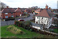
Southwold Drive
A scene typical of Nottingham municipal housing. This taken from Western Boulevard
Image: © David Lally
Taken: 28 Nov 2007
0.07 miles
2
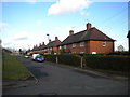
Newland Close, Wollaton
Newland Close runs parallel with Western Boulevard (part of Nottingham's ring road) near the north eastern edge of Wollaton. However, while the latter road rises to cross the Radford Junction to Trowell Junction railway line on a bridge, Newland Close remains level, and comes to an abrupt end where it meets the railway boundary fence (just visible in the distance). The terraces of four houses, with semihexagonal porches providing access to the middle dwellings, are typical of pre Second World War council estates in Nottingham, as is the circular street sign visible on the right. This estate is effectively cut in half by Western Boulevard, and is bounded to the north and east by the railway, to the south by Wollaton Road, and to the west by the now obliterated course of the Nottingham Canal.
Image: © Richard Vince
Taken: 1 Feb 2013
0.09 miles
3
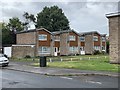
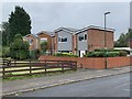
Houses on Radford Bridge Road
Built in the 1970s.
Image: © Andrew Abbott
Taken: 23 Aug 2020
0.10 miles
4
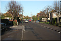
Radford Bridge Road
NCN route 6 on Radford Bridge Road
Image: © Richard Croft
Taken: 25 Nov 2011
0.11 miles
5

Western Boulevard
The Nottingham Ring Road just north of Crown Island
Image: © Alan Murray-Rust
Taken: 19 Oct 2008
0.11 miles
6
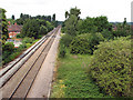
West from Western Boulevard Bridge
This is the line from Radford Junction to Trowell Junction on the Erewash Valley Line, which was built to enable trains to and from the north to avoid the bottlenecks at Trent and Toton. For a view towards here from Woodyard Lane, see Image
The railway formation here, overgrown to the right, is wider than the current double track as from the 19th century until the building of Western Boulevard and the houses either side, it was the site of Babbington Sidings, which ran parallel to the main line almost as far west as Woodyard Lane. The railway serving these sidings linked Babbington (Cinderhill) Colliery and the Nottingham Canal at a wharf immediately south of Wollaton Road and crossed this line on the level east of this bridge - see Image
For other vestiges of the Babbington Colliery line, see Image], Image], Image], Image], and Image]
Image: © John Sutton
Taken: 12 Jul 2011
0.12 miles
7
Houses on Radford Bridge Road
Dating from the 1970s and built on an old allotment site.
Image: © Andrew Abbott
Taken: 23 Aug 2020
0.12 miles
8
Newland Close, Western Boulevard
A burst of evening sunshine catches these local authority-built houses on a short cul-de-sac parallel with the Nottingham ring road.
Image: © Stephen McKay
Taken: 3 Jul 2008
0.13 miles
9
Beechdale Swimming Centre - Strange growth
There are no windows in this strange protuberance, just two air bricks in the wall parallel to the building. I wonder what it looks like from the inside.
Image: © David Lally
Taken: 28 Nov 2007
0.13 miles
10
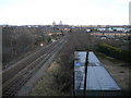
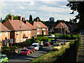
Approaching Radford Junction, Wollaton
The railway line from Trowell Junction as it approaches Radford Junction (where it joins the line from Mansfield to head through Lenton into Nottingham), seen from the Western Boulevard bridge. Ainsley Estate is to the left, while an expanse of allotments is visible on the right beyond the roof of the garage block. Two high rise blocks of flats in Radford tower conspicuously above the fairly flat skyline.
Image: © Richard Vince
Taken: 1 Feb 2013
0.14 miles