IMAGES TAKEN NEAR TO
Woodhall Road, NOTTINGHAM, NG8 1LE
Introduction
This page details the photographs taken nearby to Woodhall Road, NG8 1LE by members of the Geograph project.
The Geograph project started in 2005 with the aim of publishing, organising and preserving representative images for every square kilometre of Great Britain, Ireland and the Isle of Man.

There are currently over 7.5m images from over14,400 individuals and you can help contribute to the project by visiting https://www.geograph.org.uk
Image Map
Images are licensed for reuse under creativecommons.org/licenses/by-sa/2.0
Notes
- Clicking on the map will re-center to the selected point.
- The higher the marker number, the further away the image location is from the centre of the postcode.
Image Listing (20 Images Found)
Images are licensed for reuse under creativecommons.org/licenses/by-sa/2.0
Image
Details
Distance

2
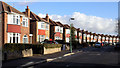
Seaford Avenue - Nottingham
I think this road will be classed as in the district of Wollaton.
This picture of houses getting smaller into the distance taken on the day when the news was of house prices getting smaller into the future!
Image: © David Lally
Taken: 29 Nov 2007
0.04 miles
3
Hollinwell Avenue, Wollaton
Detached houses on a quiet residential street.
Image: © Stephen McKay
Taken: 4 Jul 2008
0.18 miles
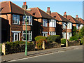
5

Bay windows on Wollaton Road
Part of the big post-war westward expansion of the city.
Image: © John Sutton
Taken: 24 Aug 2017
0.19 miles
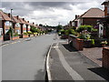
6

Wollaton Road, Wollaton
The yellow box and traffic lights are an attempt to bring some order to this complicated junction where traffic could proceed in seven different directions: either way along the main Wollaton Road carriageway, north into Woodhall Road, south into Eton Grove or via one of three service roads.
Image: © Stephen McKay
Taken: 4 Jul 2008
0.20 miles
7
Wollaton Road and the Park wall
The wall on the right is the former precinct wall of Wollaton Park. There is now housing behind it, which also bears the Wollaton Road address.
Image: © Alan Murray-Rust
Taken: 19 Oct 2008
0.22 miles
8
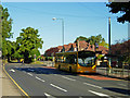
Wollaton Road, Wollaton
A Trent Barton bus on Rainbow Route 2 from Ilkeston picks up a few early morning commuters on its run into Nottingham.
Image: © Stephen McKay
Taken: 4 Jul 2008
0.22 miles
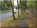
9
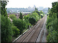
East from Woodyard Lane railway bridge
Since John Sutton took this view https://www.geograph.org.uk/photo/2473446 in 2011, some of the blocks of flats in the distance have been demolished and there has been considerable tree growth alongside the railway.
Image: © Alan Murray-Rust
Taken: 3 Aug 2021
0.22 miles
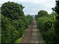
10
East from Woodyard Lane railway bridge
The line from Radford Junction (ahead) to Trowell, on the Erewash Valley Line, was built as a short cut for trains to and from the north, avoiding the bottleneck at Toton; it also served Wollaton Colliery. This is the view back towards the city, with some of the rooftops of Beechdale Estate on the left and Radford and its high-rise flats on the skyline. Years ago that skyline was dominated by Players cigarette factory, long demolished. The bridge over the railway just visible in the distance carries Western Boulevard.
Image: © John Sutton
Taken: 22 Jun 2011
0.23 miles