IMAGES TAKEN NEAR TO
Wollaton Road, NOTTINGHAM, NG8 1FU
Introduction
This page details the photographs taken nearby to Wollaton Road, NG8 1FU by members of the Geograph project.
The Geograph project started in 2005 with the aim of publishing, organising and preserving representative images for every square kilometre of Great Britain, Ireland and the Isle of Man.

There are currently over 7.5m images from over14,400 individuals and you can help contribute to the project by visiting https://www.geograph.org.uk
Image Map
Images are licensed for reuse under creativecommons.org/licenses/by-sa/2.0
Notes
- Clicking on the map will re-center to the selected point.
- The higher the marker number, the further away the image location is from the centre of the postcode.
Image Listing (64 Images Found)
Images are licensed for reuse under creativecommons.org/licenses/by-sa/2.0
Image
Details
Distance
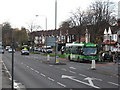
2
Wollaton Road, Wollaton
Once past the Nottingham Ring Road, the A609 Nottingham - Ilkeston Road becomes very suburban in nature as it passes through Wollaton.
Image: © Stephen McKay
Taken: 4 Jul 2008
0.04 miles
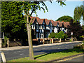
3
The corner of Wollaton Road and Ringwood Crescent
A bright May morning.
Image: © John Sutton
Taken: 4 May 2016
0.05 miles
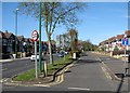
5

Wollaton: Ringwood Crescent
A u-shaped crescent, part of the big post-war housing development between Wollaton and Radford.
Image: © John Sutton
Taken: 4 May 2016
0.05 miles
6
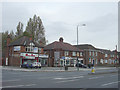
Shops on Wollaton Road
Now largely given over to fast food.
Image: © Alan Murray-Rust
Taken: 19 Oct 2008
0.07 miles
7

Middleton Boulevard shops, Wollaton Park
Row of shops at the junction of Middleton Boulevard and Wollaton Road, including Middleton Boulevard sub post office.
Image: © Stephen McKay
Taken: 4 Jul 2008
0.08 miles
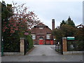
8

Wollaton Park Medical Centre
This is a new(ish) building, only open for a few months at the time of taking the photo (the previous building was completely destroyed by fire).
Image: © Oxymoron
Taken: 30 Oct 2008
0.08 miles
9
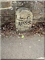
Old Boundary Marker on the A609 Wollaton Road, Nottingham
Parish Boundary Marker against the front garden wall of number 183, on the south side of the A609 Wollaton Road, Nottingham. Inscribed L P / 1855. On the former boundary of Lenton parish, which finally became part of Nottingham parish in 1897.
Milestone Society National ID: NT_NOT34pb
Image: © N Osmond
Taken: Unknown
0.08 miles
10

Wollaton Park Medical Centre
From Harrow Road.
Image: © Andrew Abbott
Taken: 3 Jun 2020
0.09 miles