IMAGES TAKEN NEAR TO
Sawyer Crescent, NG8 1BD
Introduction
This page details the photographs taken nearby to Sawyer Crescent, NG8 1BD by members of the Geograph project.
The Geograph project started in 2005 with the aim of publishing, organising and preserving representative images for every square kilometre of Great Britain, Ireland and the Isle of Man.

There are currently over 7.5m images from over14,400 individuals and you can help contribute to the project by visiting https://www.geograph.org.uk
Image Map
Images are licensed for reuse under creativecommons.org/licenses/by-sa/2.0
Notes
- Clicking on the map will re-center to the selected point.
- The higher the marker number, the further away the image location is from the centre of the postcode.
Image Listing (58 Images Found)
Images are licensed for reuse under creativecommons.org/licenses/by-sa/2.0
Image
Details
Distance
1
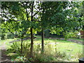
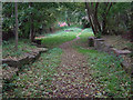
Disused Lock on the Nottingham Canal
This lock on the old Nottingham Canal, which used to run from Nottingham to Langley Mill [http://en.wikipedia.org/wiki/Nottingham_Canal], has long been filled in. It now makes a pleasant green oasis in sea of residential housing.
Image: © Oxymoron
Taken: 7 Jul 2008
0.06 miles
2
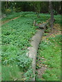
Nottingham Canal lock
The large block in the foreground is one of the heelstones for the upper pair of gates of the lock; its fellow for the lower gate can be seen in the vegetation beyond. The curved cut-out is where the heelpost of the lock gate would have turned.
Image: © Alan Murray-Rust
Taken: 19 Oct 2008
0.06 miles
3
Nottingham Canal lock
The upper entrance to the lower of the two remaining lock chambers.
Image: © Alan Murray-Rust
Taken: 19 Oct 2008
0.06 miles
4
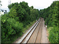
West from Woodyard Lane railway bridge
The line from Radford Junction to Trowell, on the Erewash Valley Line, was built as a short cut for trains to and from the north, avoiding the bottleneck at Toton; it also served Wollaton Colliery, beyond the trees, whose site has long been cleared. Fifty or more years ago this was an exciting place for trainspotters as expresses passed at some speed and were usually pulled by Jubilee Class engines with big brass nameplates, such as Nottingham's "Travancore" or "Hong Kong".
Image: © John Sutton
Taken: 22 Jun 2011
0.07 miles
5
Nottingham Canal locks
Looking from the lower lock up to the higher of the remaining pair.
Image: © Alan Murray-Rust
Taken: 19 Oct 2008
0.07 miles
6
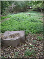
Lock weir
The curved stonework is the cill of the overflow past one of the locks on the old Nottingham Canal. The lock itself was just beyond it.
Image: © Alan Murray-Rust
Taken: 19 Oct 2008
0.07 miles
7
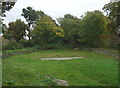
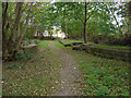
Nottingham Canal remains
Until the 1980s there was a considerable stretch of the old Nottingham Canal extant in this area. Most was built over, but this section containing the remains of two locks and two intermediate pounds was retained as open space. The locks were a substantial flight with closely spaced locks separated by generally elliptical pounds to help maintain water levels. The entrance to a lock can be seen to the right of the light tree, and to the left of it is the overflow weir with its curved cill.
Image: © Alan Murray-Rust
Taken: 19 Oct 2008
0.08 miles
8
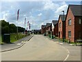
Woodyard Park ? 2
A large new housing development on the site of the former Siemens Training Centre.
Image: © Alan Murray-Rust
Taken: 3 Aug 2021
0.09 miles
9
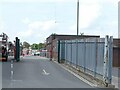
Primary Substation, Bilborough
Taken on an attempt to recreate this 'First' for the square https://www.geograph.org.uk/photo/18959 . Not replicable without access to the upper floor of the Nottingham City Council depot at Woolsthorpe Close!
Image: © Alan Murray-Rust
Taken: 3 Aug 2021
0.11 miles
10
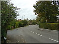
Lambourne Drive
1980s housing development, largely along the line of the old Nottingham Canal.
Image: © Alan Murray-Rust
Taken: 19 Oct 2008
0.12 miles