IMAGES TAKEN NEAR TO
Charnock Avenue, NOTTINGHAM, NG8 1AG
Introduction
This page details the photographs taken nearby to Charnock Avenue, NG8 1AG by members of the Geograph project.
The Geograph project started in 2005 with the aim of publishing, organising and preserving representative images for every square kilometre of Great Britain, Ireland and the Isle of Man.

There are currently over 7.5m images from over14,400 individuals and you can help contribute to the project by visiting https://www.geograph.org.uk
Image Map
Images are licensed for reuse under creativecommons.org/licenses/by-sa/2.0
Notes
- Clicking on the map will re-center to the selected point.
- The higher the marker number, the further away the image location is from the centre of the postcode.
Image Listing (126 Images Found)
Images are licensed for reuse under creativecommons.org/licenses/by-sa/2.0
Image
Details
Distance
1
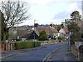
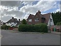
Charnock Avenue
Part of the Wollaton Park Estate created under the auspices of the chairman of the Nottingham City Council's Housing Committee, William Crane in the 1920s. http://cms.nottinghamshire.gov.uk/home/leisure/archives/exhibitions/buildingforlifeandleisure/cranehouses.htm
Image: © Alan Murray-Rust
Taken: 16 Feb 2014
0.02 miles
2
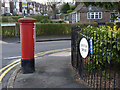
Orston Green postbox ref NG8 483
Standard GR pillar box. Note also the distinctive circular road name sign used by Nottingham City on council-developed estates.
Image: © Alan Murray-Rust
Taken: 16 Feb 2014
0.03 miles
3
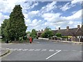
Orston Green
At the junction of Orston Drive and Charnock Avenue
Image: © Andrew Abbott
Taken: 22 May 2020
0.03 miles
4
Wollaton Hall Drive
Behind Lenton Lodge
Image: © Andrew Abbott
Taken: 22 May 2020
0.06 miles
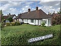
5
Houses on Charnock Avenue
In Wollaton, Nottingham.
Image: © Andrew Abbott
Taken: 22 May 2020
0.07 miles
6
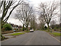
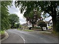
Wollaton Hall Drive
Although the name suggests that this was the original drive to Wollaton Hall, and it maintains the alignment with Lime Tree Avenue in Wollaton Park, this is not the case. The original drive followed a more curving route to the north, and the current road was created when housing was developed in the area during the Inter-war period. The avenue trees are a mixture of ordinary and copper beeches. Clearly many were pollarded at some stage before being allowed to re-grow, resulting in long upward-reaching branches.
Image: © Alan Murray-Rust
Taken: 9 Feb 2014
0.08 miles
7
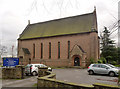
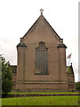
St Mary's Church, Wollaton
A relatively simple building in brick, opened in 1939. It is one of a pair of churches (cf.http://www.geograph.org.uk/photo/3845598) designed by T Cecil Howitt, the local Nottingham architect, to serve the expanding housing developments on the west side of Nottingham resulting from the 1933 extension of the City. Listed Grade II.
Image: © Alan Murray-Rust
Taken: 9 Feb 2014
0.08 miles
8
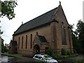
St Mary's Church, Wollaton Park
Built 1937-39 to the designs of the architect Thomas Cecil Howitt.
Image: © Andrew Abbott
Taken: 6 Sep 2008
0.08 miles
9
St Mary's Church, Wollaton
The east end seen from Wollaton Hall Drive. See http://www.geograph.org.uk/photo/3844259 for more information.
Image: © Alan Murray-Rust
Taken: 9 Feb 2014
0.08 miles
10
Charnock Avenue
House on the corner of Middleton Boulevard and Charnock Avenue
Image: © Andrew Abbott
Taken: 22 May 2020
0.09 miles