IMAGES TAKEN NEAR TO
Leslie Avenue, NOTTINGHAM, NG7 6PW
Introduction
This page details the photographs taken nearby to Leslie Avenue, NG7 6PW by members of the Geograph project.
The Geograph project started in 2005 with the aim of publishing, organising and preserving representative images for every square kilometre of Great Britain, Ireland and the Isle of Man.

There are currently over 7.5m images from over14,400 individuals and you can help contribute to the project by visiting https://www.geograph.org.uk
Image Map
Images are licensed for reuse under creativecommons.org/licenses/by-sa/2.0
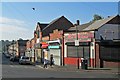
Notes
- Clicking on the map will re-center to the selected point.
- The higher the marker number, the further away the image location is from the centre of the postcode.
Image Listing (179 Images Found)
Images are licensed for reuse under creativecommons.org/licenses/by-sa/2.0
Image
Details
Distance
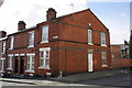
1
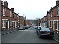
Leslie Road, Forest Fields
Looking south east from Alberta Terrace.
Image: © JThomas
Taken: 27 Mar 2017
0.02 miles
4
Berridge Road: the Jameah Fatimah Mosque
A view from the corner of Berridge Road East and Leslie Road. The mosque was originally a cinema, The Apollo.
Image: © John Sutton
Taken: 12 May 2014
0.03 miles
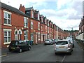
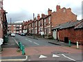
5
Junction of Gladstone Street and Leslie Road
The corner houses are #232 Gladstone Street and #141 Leslie Road.
Image: © Roger Templeman
Taken: 31 Mar 2013
0.04 miles
6
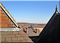
A view from the roof of Forest Fields Primary School
A view across the rooftops of Forest Fields, Sherwood Rise and Mapperley Park, taken during a visit by former pupils of the two grammar schools which once occupied the building which is now Forest Fields Primary School. The large building a few streets away is the former Apollo Cinema, now the Jameah Fatimah mosque.
For the school's Grade II listing, see http://www.britishlistedbuildings.co.uk/en-458870-clarendon-college-berridge-centre- .
Image: © John Sutton
Taken: 9 Feb 2015
0.05 miles
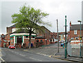
8
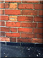
Ordnance Survey BOGOF offer?
Ordnance Survey cut mark benchmarks on RKD Service Station at junction of Leslie Road and Berridge Road. The mark is described on the Bench Mark Database at http://www.bench-marks.org.uk/bm35199.
Image: © Roger Templeman
Taken: 10 Aug 2010
0.05 miles
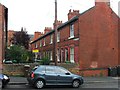
9

Junction of Berridge Road and Leslie Road
There are two OS benchmarks Image on the garage building wall left of the lamp post
Image: © Roger Templeman
Taken: 31 Mar 2013
0.05 miles
10
Forest Fields: hurrying to school on the first day of term
This is the corner of Berridge Road and Leslie Road, looking downhill towards The Forest from outside the mosque, formerly the Apollo Cinema. (I have the feeling Mr Chips used to be the café we went to at lunchtime - aiming to become pinball wizards - when sixth-formers at Forest Fields Grammar School in the mid 1960s.)
Image: © John Sutton
Taken: 5 Sep 2013
0.05 miles