IMAGES TAKEN NEAR TO
Fourth Avenue, NOTTINGHAM, NG7 6JB
Introduction
This page details the photographs taken nearby to Fourth Avenue, NG7 6JB by members of the Geograph project.
The Geograph project started in 2005 with the aim of publishing, organising and preserving representative images for every square kilometre of Great Britain, Ireland and the Isle of Man.

There are currently over 7.5m images from over14,400 individuals and you can help contribute to the project by visiting https://www.geograph.org.uk
Image Map
Images are licensed for reuse under creativecommons.org/licenses/by-sa/2.0
Notes
- Clicking on the map will re-center to the selected point.
- The higher the marker number, the further away the image location is from the centre of the postcode.
Image Listing (169 Images Found)
Images are licensed for reuse under creativecommons.org/licenses/by-sa/2.0
Image
Details
Distance
1
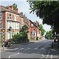
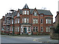
Sherwood Rise: Fourth Avenue
The pleasing villas on First, Second, Third and Fourth Avenues were some of the first houses built north of The Forest as Nottingham expanded after the Enclosure Act of 1845. The houses face south and the road approach is from the rear.
Image: © John Sutton
Taken: 6 Jul 2015
0.01 miles
2
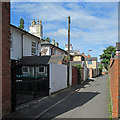
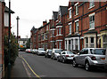
Sherwood Rise, 4th Avenue
This narrow and nondescript lane actually provides access to a number of quite attractive Victorian villas with south-facing frontages.
Image: © Alan Murray-Rust
Taken: 27 Aug 2009
0.02 miles
3
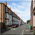
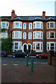
Sherwood Rise: Alberta Terrace
Looking from Sherwood Rise towards Gladstone Street and Forest Fields. Any number of houses of this kind were built as Nottingham mushroomed in the last twenty years of the nineteenth century.
Image: © John Sutton
Taken: 6 Jul 2015
0.02 miles
4
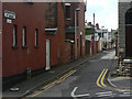
Sherwood Rise crossroads
Looking east across Sherwood Rise to Hamilton Road from Alberta Terrace.
Image: © Roger Templeman
Taken: 10 Aug 2010
0.03 miles
5
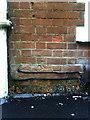
Benchmark on #1 Alberta Terrace
Ordnance Survey 1986 cut mark benchmark which is described on the Bench Mark Database at http://www.bench-marks.org.uk/bm35126
Image: © Roger Templeman
Taken: 10 Aug 2010
0.03 miles
6
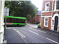
Sherwood Rise
Looking up the hill towards New Basford from near the corner of Alberta Terrace.
Image: © John Sutton
Taken: 6 Jul 2015
0.04 miles
7
Beech Avenue - looking east
The northern edge of Forest Fields, where it shades into New Basford. The typical three-storey terraced houses at this end of the road date, like much of the area, from the end of the 19th century. This is the view towards Sherwood Rise.
Image: © John Sutton
Taken: 27 Apr 2011
0.04 miles
8
Nos. 20 to 26 Berridge Road East
2nd floor windows 2nd house from the right was my home for 2nd year at Nottingham University.
This house was always colder inside than out, even in the middle of winter when we all had our gas fires on full. We would emerge from the front door and take our coats off!
There was a hole in the roof in those days through which pigeons would enter to make the loft-space their home.
I would be woken in the mornings (to realise I'd just missed another lecture) by their scratching and scraping on my ceiling.
Image: © David Lally
Taken: 23 Jun 2008
0.04 miles
10
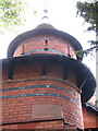
Norris Ladies' Home: corner turret
Note pointy French chateau roof and the stone carved "Watson Fothergill Architect".
Image: © John Sutton
Taken: 11 Oct 2006
0.04 miles