IMAGES TAKEN NEAR TO
Berridge Road, NOTTINGHAM, NG7 6HS
Introduction
This page details the photographs taken nearby to Berridge Road, NG7 6HS by members of the Geograph project.
The Geograph project started in 2005 with the aim of publishing, organising and preserving representative images for every square kilometre of Great Britain, Ireland and the Isle of Man.

There are currently over 7.5m images from over14,400 individuals and you can help contribute to the project by visiting https://www.geograph.org.uk
Image Map
Images are licensed for reuse under creativecommons.org/licenses/by-sa/2.0
Notes
- Clicking on the map will re-center to the selected point.
- The higher the marker number, the further away the image location is from the centre of the postcode.
Image Listing (174 Images Found)
Images are licensed for reuse under creativecommons.org/licenses/by-sa/2.0
Image
Details
Distance
1
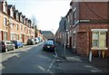
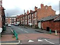
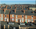
Berridge Road and Stanley Road
Looking into the sun towards the former Apollo Cinema, now a mosque, on the corner of Leslie Road. The house on the corner of Stanley Road was once a corner shop. Its door is now bricked up. This view was familiar to me as I turned left to Forest Fields Grammar School (absent only one half-day, 1959-66).
Image: © John Sutton
Taken: 1 May 2013
0.01 miles
2
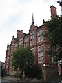
Former Grammar School, Stanley Road
When High Pavement Grammar School moved to new buildings in 1956 a new, co-educational grammar school, Forest Fields, opened in the Stanley Road building. Forest Fields moved to Carlton Hill some time in the 1970s and now is no more.
Image: © John Sutton
Taken: 11 Oct 2006
0.03 miles
3
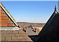
A view from the roof of Forest Fields Primary School
A view across the rooftops of Forest Fields, Sherwood Rise and Mapperley Park, taken during a visit by former pupils of the two grammar schools which once occupied the building which is now Forest Fields Primary School. The large building a few streets away is the former Apollo Cinema, now the Jameah Fatimah mosque.
For the school's Grade II listing, see http://www.britishlistedbuildings.co.uk/en-458870-clarendon-college-berridge-centre- .
Image: © John Sutton
Taken: 9 Feb 2015
0.03 miles
6
Forest Fields: school restoration
A view from Sturton Street of the rear of what was successively High Pavement and Forest Fields Grammar Schools, now being refurbished to house Forest Fields Primary School. When I was at FFGS from 1959-66 the art room (presided over by the wonderful Mrs Marjorie Macmillan) was at the top of the wing straight ahead, with the library below it. The tall windows to the right were those of the classrooms reached from the upper and lower halls, which were used for assemblies and PE.
Image: © John Sutton
Taken: 23 Aug 2013
0.03 miles
7
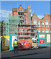
Forest Fields: site entrance and former physics lab
The poster on the left announces that the City Council is "proud to be investing in the expansion of Forest Fields Primary and Nursery School" - in the buildings which formerly housed High Pavement and then Forest Fields Grammar Schools. This picture may be of interest to others who, like me, were educated here. The two doors next to the yellow site gate are in the end of what in my time was the boys' toilets. The building whose corrugated red-oxide end gable shows above the wall was the physics laboratory where it rapidly became obvious to me that any talents I had lay in the arts rather than the sciences; I think the bi-metallic strip was about the last thing I understood, in the third week of the first year....
Image: © John Sutton
Taken: 27 Sep 2013
0.03 miles
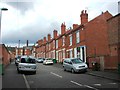
8
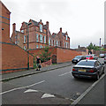
Sturton Street and the rear of Forest Fields Primary School
The building dates from the 1890s and was successively High Pavement and Forest Fields Grammar Schools, then Claremont Secondary. The new stretch of wall further up Sturton Street, in paler brick, is where the biology and chemistry laboratories were in my time at FFGS.
Earlier views from the other end of Sturton Street:
Image] (2012)
Image] (2013)
Image: © John Sutton
Taken: 29 Aug 2017
0.03 miles
9
Over Forest Fields rooftops
A view from an upper-floor window in Forest Fields Primary School, taken during a visit by former pupils of the two grammar schools which once occupied the building. Sturton Street is in the foreground, Sherwood Rise in the middle distance, Mapperley Park beyond and Mapperley Plains on the skyline. The large building a few streets away on the right is the former Apollo Cinema, now the Jameah Fatimah mosque.
Image: © John Sutton
Taken: 9 Feb 2015
0.03 miles
10
Forest Fields Primary School playground
The former grammar-school building on Stanley Road has been revamped as Forest Fields Primary's new home. When I was at Forest Fields Grammar School (1959-66), this was the site of the physics lab and huts 1 and 2 (1B's form room in my time). Now it's gone, I'm glad I photographed part of the lab in September 2013: Image
Image: © John Sutton
Taken: 12 May 2014
0.03 miles