IMAGES TAKEN NEAR TO
Russell Road, NOTTINGHAM, NG7 6GW
Introduction
This page details the photographs taken nearby to Russell Road, NG7 6GW by members of the Geograph project.
The Geograph project started in 2005 with the aim of publishing, organising and preserving representative images for every square kilometre of Great Britain, Ireland and the Isle of Man.

There are currently over 7.5m images from over14,400 individuals and you can help contribute to the project by visiting https://www.geograph.org.uk
Image Map
Images are licensed for reuse under creativecommons.org/licenses/by-sa/2.0
Notes
- Clicking on the map will re-center to the selected point.
- The higher the marker number, the further away the image location is from the centre of the postcode.
Image Listing (190 Images Found)
Images are licensed for reuse under creativecommons.org/licenses/by-sa/2.0
Image
Details
Distance
1
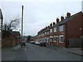
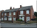
Beaconsfield Street
From the corner of Russell Road.
Image: © John Sutton
Taken: 24 Sep 2009
0.01 miles
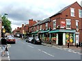
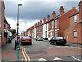
2
Ewart Road
Looking down towards Berridge Road, with The Forest in the background.
Image: © John Sutton
Taken: 24 Sep 2009
0.03 miles
5
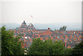
Forest Fields rooftops and Shipstone's stars
The former Shipstone's Brewery, with its two distinctive red stars, shows above the slate roofs of Forest Fields in this zoom shot taken from the Forest on a grey September morning.
Image: © John Sutton
Taken: 9 Sep 2010
0.05 miles
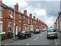
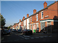
7
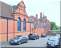
Nottingham, NG7 (Forest)
The Stanley Road entrance of what was, until 1956, was the High Pavement Boys' Grammar School. After this High Pavement School decamped to a new building in Bestwood and this building became the co-educational Forest Fields Grammar School. It is now a training location used by the Nottingham Fire and Rescue Service.
Image: © David Hallam-Jones
Taken: 24 Jun 2012
0.06 miles
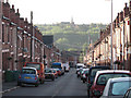
8
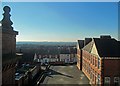
The western suburbs from Forest Fields
A view from an upper-floor window taken against the light early on a brilliant February afternoon, during a visit by former pupils of the two grammar schools which once occupied the building which is now Forest Fields Primary School. The hills around Trowell and Strelley are on the skyline, beyond the rooftops of Radford, Bilborough and Wollaton. The distinctive silhouette of Wollaton Hall shows more obviously on the skyline to the left in larger versions of this image. The building in the right foreground was known as T Block in grammar-school days. In those days there were wooden dinner huts in the playground in front of it.
Image: © John Sutton
Taken: 9 Feb 2015
0.06 miles