IMAGES TAKEN NEAR TO
Hyson Close, NOTTINGHAM, NG7 6EX
Introduction
This page details the photographs taken nearby to Hyson Close, NG7 6EX by members of the Geograph project.
The Geograph project started in 2005 with the aim of publishing, organising and preserving representative images for every square kilometre of Great Britain, Ireland and the Isle of Man.

There are currently over 7.5m images from over14,400 individuals and you can help contribute to the project by visiting https://www.geograph.org.uk
Image Map
Images are licensed for reuse under creativecommons.org/licenses/by-sa/2.0
Notes
- Clicking on the map will re-center to the selected point.
- The higher the marker number, the further away the image location is from the centre of the postcode.
Image Listing (211 Images Found)
Images are licensed for reuse under creativecommons.org/licenses/by-sa/2.0
Image
Details
Distance
1
Belvedere Avenue
A development off Berridge Road Central.
Image: © John Sutton
Taken: 24 Sep 2009
0.03 miles
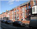
2
Hyson Green: Glenstone Court, Radford Road
Image: © John Sutton
Taken: 20 Nov 2009
0.04 miles
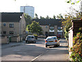
3

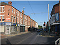
Hyson Green: traffic on Radford Road
The area to the right, between Radford Road and Noel Street, was cleared in the 1960s - see Image Like their counterparts at Balloon Wood and Basford, the brutalist deck-access flats which replaced the Victorian streets did not last very long: an Asda supermarket and conventional brick-built houses and flats have replaced them. Southbound trams run along Radford Road. The poles support the tram wires. The Victorian shops in the middle distance to the left of centre are on the corner of Berridge Road Central.
Image: © John Sutton
Taken: 20 Nov 2009
0.04 miles
4
Berridge Road Central
Victorian semi-detached houses near the junction with Radford Road.
Image: © John Sutton
Taken: 24 Sep 2009
0.05 miles
5
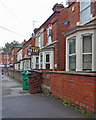
Hyson Green: dustbin aphorisms on Berridge Road
Looking towards Radford Road on a dreary September morning. Make what you will of the brown bin's "Arrogance is the debris of a blocked mind". Similarly portentous pronouncements appear on other bins and placards on these houses on Berridge Road Central. (They weren't there when I walked along here to and from school in the 1960s.)
Image: © John Sutton
Taken: 12 Sep 2018
0.05 miles
6
Junction of Radford Road and Berridge Road
The truncated Berridge Road West is on the left and Berridge Road Central on the right.
Image: © John Sutton
Taken: 24 Sep 2009
0.05 miles
7
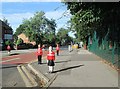
Berridge Road: traffic calming
Outside Scotholme Primary School, on a sunny morning in the school holidays.
Image: © John Sutton
Taken: 23 Aug 2013
0.05 miles
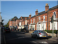
8
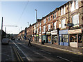
Radford Road
Looking towards Hyson Green. The southbound tram line down Radford Road has inspired the jokey name of the sandwich shop on the right. "Tramwiches" is a perfect rhyme as sandwich is pronounced "samwidge" by true Nottinghamians. Apart from a church and two cinemas, Radford Road used to be more or less all three-storeyed shops like these on both sides from Bentinck Road to Wilkinson Street. Those on the east side between Berridge Road and Gregory Boulevard were demolished a while ago.
Image: © John Sutton
Taken: 24 Sep 2009
0.06 miles
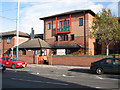
9
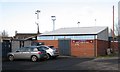
Radford Sports and Social Club
At the Selhurst Street football ground, home of The Pheasants. St Stephen's Church on Bobbers Mill Road is in the background to the left, its spindly spire partly hidden by one of the floodlight pylons. The ground stands on what was once part of the now-truncated Berridge Road West.
Image: © John Sutton
Taken: 20 Nov 2009
0.06 miles
10
Radford Road
This modern block replaced the old Lenos Cinema.
Image: © John Sutton
Taken: 20 Nov 2009
0.07 miles