IMAGES TAKEN NEAR TO
Lynmouth Crescent, NOTTINGHAM, NG7 5RB
Introduction
This page details the photographs taken nearby to Lynmouth Crescent, NG7 5RB by members of the Geograph project.
The Geograph project started in 2005 with the aim of publishing, organising and preserving representative images for every square kilometre of Great Britain, Ireland and the Isle of Man.

There are currently over 7.5m images from over14,400 individuals and you can help contribute to the project by visiting https://www.geograph.org.uk
Image Map
Images are licensed for reuse under creativecommons.org/licenses/by-sa/2.0
Notes
- Clicking on the map will re-center to the selected point.
- The higher the marker number, the further away the image location is from the centre of the postcode.
Image Listing (206 Images Found)
Images are licensed for reuse under creativecommons.org/licenses/by-sa/2.0
Image
Details
Distance
1
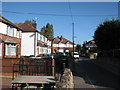
Lynmouth Crescent
Straight, with turning circles at their ends, neither Lynmouth Crescent nor Truro Crescent is a true crescent, as I learned at Berridge Road Junior School.
Image: © John Sutton
Taken: 24 Sep 2009
0.02 miles
2
Lynmouth Crescent: from end to end
Narrow roads and turning circles laid out in the 1930s with the small cars of that time in mind. The Dartmeet Court flats on the extreme left were built on the site of a woodyard.
Image: © John Sutton
Taken: 14 Sep 2012
0.02 miles
3
Newquay Avenue: 2023 Coronation decorations
I lived on Newquay Avenue as a child and remember the flags and bunting flying from almost every house on Coronation Day in 1953. Seventy years on times have changed and I saw almost no outward signs of enthusiasm for the event in Nottingham in the days before it. This time the house behind the white car was the only one on Newquay Avenue with flags and pictures of the King.
Image: © John Sutton
Taken: 5 May 2023
0.03 miles
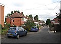
4

A May morning in Newquay Avenue
Looking towards Truro and Lynmouth Crescents. The flat-topped houses seen through the trees in the distance on the right are on Poulter Close, built on the site of Radford Colliery on the other side of the River Leen.
Image: © John Sutton
Taken: 11 May 2012
0.03 miles
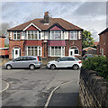
5
Newquay Avenue and Lynmouth Crescent
To see how much (or how little) this scene has changed in the last fifty-odd years, see Image
Image: © John Sutton
Taken: 29 Apr 2011
0.03 miles
6

Along Newquay Avenue
Looking towards the corner of Truro Crescent (left) and Lynmouth Crescent at the end of this cul-de-sac off Alfreton Road, an area which was developed in the 1930s.
Image: © John Sutton
Taken: 30 Apr 2022
0.03 miles
7
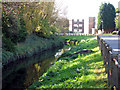
River Leen at Bobbers Mill
Poulter Close and Greet Court, south-west of Bobbers Mill Bridge, are on the site of Radford Colliery, which closed in the 1960s. The Leen runs behind Lynmouth Crescent (to the left, behind the trees), then south through Old Radford and Lenton before joining the Trent. The concrete-post-and-iron-rail fence, which shows in old photographs, is the only surviving evidence of the colliery here. I remember it well, and seeing the colliers coming on and off shift, as we fished for tiddlers from the left bank.
Image: © John Sutton
Taken: 24 Sep 2009
0.03 miles
8
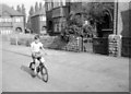
Newquay Avenue, 1955
For a view of the street where I lived as a child taken 55 years after this one, see Image Much is the same (the houses themselves, and their Bulwell stone garden walls), but much has changed. The wooden gates, windows and front doors (all various species of mid green in the mid fifties) have all been replaced, and thanks to the Clean Air Act, the end of steam on the nearby railway and the closure of Radford Colliery (which was behind the poplar trees visible between and above the houses on Lynmouth Crescent) the pebble-dash on the upper storeys now stays bright white and not the smoky grey it was then.
The lad on the bike is me, proudly riding my first (second-hand) two-wheeled bike past our house (offstage left). Mum’s writing on the back of the tiny Brownie print dates it July 1955 and notes that I am six – so it’s before my birthday at the end of the month. The bike was maroon – but only I can see this black-and-white snap in colour....
Image: © Sutton family album
Taken: Unknown
0.03 miles
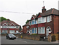
9
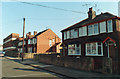
Newquay Avenue: south side, 1993
The gas lamps had gone, the paintwork was brighter and the Capitol Cinema (extreme left, on the corner of Churchfield Lane) was a bingo hall, but new garden gates, doors and windows apart, all was still much as it had been in the fifties and sixties, when I lived here.
Image: © John Sutton
Taken: 13 Mar 1993
0.03 miles
10
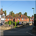
Down Truro Crescent
To a four-year-old this gentle slope seemed very steep. I lived at the house in the centre of the picture for the first twenty years of my life. The rear extension and the garage at the side have been added since my parents moved in 1968.
Image: © John Sutton
Taken: 25 Sep 2015
0.04 miles