IMAGES TAKEN NEAR TO
Grimston Road, NOTTINGHAM, NG7 5QX
Introduction
This page details the photographs taken nearby to Grimston Road, NG7 5QX by members of the Geograph project.
The Geograph project started in 2005 with the aim of publishing, organising and preserving representative images for every square kilometre of Great Britain, Ireland and the Isle of Man.

There are currently over 7.5m images from over14,400 individuals and you can help contribute to the project by visiting https://www.geograph.org.uk
Image Map
Images are licensed for reuse under creativecommons.org/licenses/by-sa/2.0
Notes
- Clicking on the map will re-center to the selected point.
- The higher the marker number, the further away the image location is from the centre of the postcode.
Image Listing (252 Images Found)
Images are licensed for reuse under creativecommons.org/licenses/by-sa/2.0
Image
Details
Distance
1
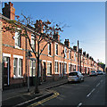
Wordsworth Road
One of the terraced streets between Churchfield Lane and Radford Boulevard, photographed on a bright late-September morning.
Image: © John Sutton
Taken: 25 Sep 2015
0.03 miles
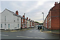
2
Wordsworth Road housebacks
Seen across Churchfield Lane from the corner of Kingsford Avenue. This was once on the western edge of Victorian and Edwardian Nottingham. The streets to the west of Churchfield Lane (behind the camera), extending as far as the River Leen, date from the late 1930s.
Image: © John Sutton
Taken: 12 Jul 2011
0.03 miles
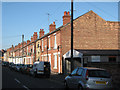
3
Along Grimston Road
Looking towards Radford Boulevard and Alfreton Road from Churchfield Lane on a grey September morning. Until the late 1930s this was the edge of Nottingham in these parts. Behind the camera are houses built just before the War as the city began the huge westward expansion which continued in the fifties and sixties. The white house on the left used to be a corner sweet shop.
Image: © John Sutton
Taken: 12 Sep 2018
0.03 miles
5
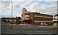
Former Capitol Cinema, Churchfield Lane
Built in 1936 and now a Grade II listed building. Since retiring as a cinema it saw life as a bingo hall but now is advertised as a church.
Image: © Mick Garratt
Taken: 29 Aug 2007
0.04 miles
6
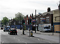
Shops on Alfreton Road
I don't suppose this little parade of shops is known as The Front any more, as it was when I was a child in the 1950s. In those days the boarded-up cement-fronted Art Deco building on the right housed Craft's fish-and-chip shop. The gabled brick buildings were once home (among others) to an exciting toy shop and Searcy's radio shop. The Co-op greengrocery, the chemist's and others I can't remember, further down, have been demolished.
Image: © John Sutton
Taken: 19 May 2010
0.05 miles
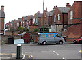
7
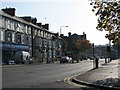
Alfreton Road
Taken from the corner of Churchfield Lane.
Image: © John Sutton
Taken: 24 Sep 2009
0.05 miles
8
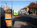
Phone Home from Alfreton Road
Evidence of the area's rich cultural diversity. Some of the shops on the left, next to the bus stop, have recently been demolished. The turn into Grundy Street is on the right, behind the white van.
Image: © John Sutton
Taken: 24 Sep 2009
0.05 miles
9
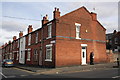
Junction of Grimston Road and Churchfield Lane
There is an OS benchmark Image on the corner of the near house
Image: © Roger Templeman
Taken: 31 Mar 2013
0.05 miles
10
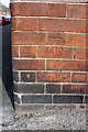
Benchmark on #75 Grimston Road
Ordnance Survey cut mark benchmark described on the Bench Mark Database at http://www.bench-marks.org.uk/bm47871
Image: © Roger Templeman
Taken: 31 Mar 2013
0.05 miles