IMAGES TAKEN NEAR TO
Churchfield Lane, NOTTINGHAM, NG7 5QS
Introduction
This page details the photographs taken nearby to Churchfield Lane, NG7 5QS by members of the Geograph project.
The Geograph project started in 2005 with the aim of publishing, organising and preserving representative images for every square kilometre of Great Britain, Ireland and the Isle of Man.

There are currently over 7.5m images from over14,400 individuals and you can help contribute to the project by visiting https://www.geograph.org.uk
Image Map
Images are licensed for reuse under creativecommons.org/licenses/by-sa/2.0
Notes
- Clicking on the map will re-center to the selected point.
- The higher the marker number, the further away the image location is from the centre of the postcode.
Image Listing (239 Images Found)
Images are licensed for reuse under creativecommons.org/licenses/by-sa/2.0
Image
Details
Distance
1
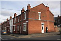
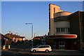
Churchfield Lane
The former Capitol Cinema, now a gospel church, is on the corner of Churchfield Lane and Newquay Avenue.
Image: © John Sutton
Taken: 24 Sep 2009
0.02 miles
2
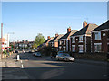
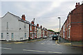
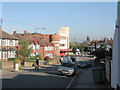
Up Churchfield Lane
Much of this part of Nottingham was built between the wars as the city started to expand westwards - a process which accelerated after the war.
Image: © John Sutton
Taken: 25 Aug 2021
0.02 miles
3
Junction of Grimston Road and Churchfield Lane
There is an OS benchmark Image on the corner of the near house
Image: © Roger Templeman
Taken: 31 Mar 2013
0.02 miles
4
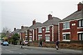
Houses on Churchfield Lane
These houses were built, I think, in the 1920s, pre-dating those behind the camera. As a small child growing up in nearby Newquay Avenue I was intrigued by the quoins (though then I didn't know what they were called) and the red stars. Like all Nottingham houses with any pretensions to gentility, they have Bulwell stone garden walls.
Image: © John Sutton
Taken: 20 Apr 2015
0.03 miles
5
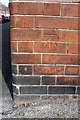
Benchmark on #75 Grimston Road
Ordnance Survey cut mark benchmark described on the Bench Mark Database at http://www.bench-marks.org.uk/bm47871
Image: © Roger Templeman
Taken: 31 Mar 2013
0.03 miles
6
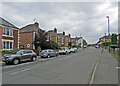
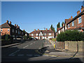
Along Grimston Road
Looking towards Radford Boulevard and Alfreton Road from Churchfield Lane on a grey September morning. Until the late 1930s this was the edge of Nottingham in these parts. Behind the camera are houses built just before the War as the city began the huge westward expansion which continued in the fifties and sixties. The white house on the left used to be a corner sweet shop.
Image: © John Sutton
Taken: 12 Sep 2018
0.03 miles
8
The Capitol Cinema & Churchfield Lane
See also Image
Image: © David Lally
Taken: 1 Jul 2009
0.04 miles
9
Churchfield Lane
The semi-detached houses on the west side were built in the late 1930s and are the same design as those on nearby Newquay Avenue.
Image: © John Sutton
Taken: 24 Sep 2009
0.04 miles
10
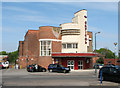
The former Capitol Cinema
Built in the late 1930s at the same time as many of the nearby semi-detached houses, the voluptuously-curved Art Deco Capitol (where I saw Olivier's Richard III and immediately fell for Shakespeare) at the corner of Newquay Avenue and Churchfield Lane is now the Mount Zion Millennium City Church.
Image: © John Sutton
Taken: 19 May 2010
0.04 miles