IMAGES TAKEN NEAR TO
Glentworth Road, NOTTINGHAM, NG7 5QN
Introduction
This page details the photographs taken nearby to Glentworth Road, NG7 5QN by members of the Geograph project.
The Geograph project started in 2005 with the aim of publishing, organising and preserving representative images for every square kilometre of Great Britain, Ireland and the Isle of Man.

There are currently over 7.5m images from over14,400 individuals and you can help contribute to the project by visiting https://www.geograph.org.uk
Image Map (Loading...)


Getting Data...Please wait
Leaflet Map data © OpenStreetMap
Images are licensed for reuse under creativecommons.org/licenses/by-sa/2.0
Notes
- Clicking on the map will re-center to the selected point.
- The higher the marker number, the further away the image location is from the centre of the postcode.
Image Listing (253 Images Found)
Images are licensed for reuse under creativecommons.org/licenses/by-sa/2.0
Image
Details
Distance
1
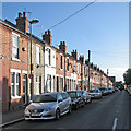
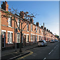
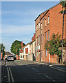
Glentworth Road
One of the terraced streets between Churchfield Lane and Radford Boulevard, photographed on a bright late-September morning.
Image: © John Sutton
Taken: 25 Sep 2015
0.01 miles
2
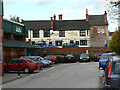
The Pheasant Inn
Attractive traditional survival in an area which has been heavily redeveloped.
Image: © Alan Murray-Rust
Taken: 7 Nov 2008
0.03 miles
4
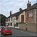
Prospect Street: The Pheasant Inn
Image: © John Sutton
Taken: 7 Sep 2016
0.04 miles
5
Wordsworth Road
One of the terraced streets between Churchfield Lane and Radford Boulevard, photographed on a bright late-September morning.
Image: © John Sutton
Taken: 25 Sep 2015
0.04 miles
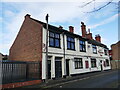
6
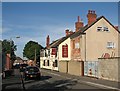
Prospect Street and The Pheasant Inn
Prospect Street runs between Radford Boulevard and Churchfield Lane. The Pheasant predates the late Victorian streets nearby. It was once in the shadow of Player's Castle Tobacco Factory, now demolished and the site of Castle Retail Park (behind the railings on the left).
Image: © John Sutton
Taken: 13 Sep 2012
0.04 miles
7
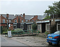
Radford Care Group
"A day centre for the older community" on land between Prospect Street and Glentworth Road (ahead), built in 1979 and photographed on a drab rainy morning 36 years later.
Image: © John Sutton
Taken: 2 Jun 2015
0.04 miles
9
Along Prospect Street
Prospect Street runs between Radford Boulevard and Churchfield Lane (ahead). The Pheasant Inn predates the late Victorian streets nearby. It was once in the shadow of Player's Castle Tobacco Factory, now demolished and the site of Castle Retail Park (offstage left).
Image: © John Sutton
Taken: 13 Sep 2012
0.04 miles
10
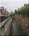
Churchfield Lane: up the entry
The passage leading to the back yards of houses on Wordsworth Road. The yards of the houses on Glentworth Road (on the right) are further up the hill and supported by a substantial Bulwell stone retaining wall. It was a wet and drab early-summer morning in Radford, but the day cleared up later.
Image: © John Sutton
Taken: 2 Jun 2015
0.05 miles