IMAGES TAKEN NEAR TO
Kenslow Avenue, NOTTINGHAM, NG7 5LD
Introduction
This page details the photographs taken nearby to Kenslow Avenue, NG7 5LD by members of the Geograph project.
The Geograph project started in 2005 with the aim of publishing, organising and preserving representative images for every square kilometre of Great Britain, Ireland and the Isle of Man.

There are currently over 7.5m images from over14,400 individuals and you can help contribute to the project by visiting https://www.geograph.org.uk
Image Map
Images are licensed for reuse under creativecommons.org/licenses/by-sa/2.0
Notes
- Clicking on the map will re-center to the selected point.
- The higher the marker number, the further away the image location is from the centre of the postcode.
Image Listing (230 Images Found)
Images are licensed for reuse under creativecommons.org/licenses/by-sa/2.0
Image
Details
Distance
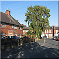
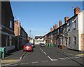
1
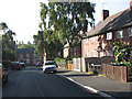
Kenslow Avenue
Looking towards Brushfield Street. Kenslow Avenue is the only street of inter-wars council houses in an area of Victorian terraces.
Image: © John Sutton
Taken: 24 Sep 2009
0.00 miles
2
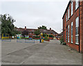
Berridge Road playground
It was the summer holiday, so the playground was deserted. When I learned a lot of what I know here in the 1950s there was no play equipment (we kicked a bald tennis ball around or played marbles) and the outside toilets were in the corner where the mural is. In those days there were dinner huts on the far (Kenslow Avenue) side.
Image: © John Sutton
Taken: 29 Aug 2017
0.03 miles
4
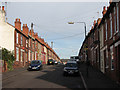
Up Berridge Road West
Looking north from the corner of Oakland Street, with Victorian villas on the left and council-built houses on the right.
Image: © John Sutton
Taken: 25 Aug 2021
0.04 miles
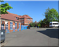
5
Berridge Primary and Nursery School
I don't have much time for the pronouncements of Ofsted, but I was pleased to read that Berridge is considered "good" with "outstanding" features, just as it was by local people when I was a pupil here in the 1950s.
Image: © John Sutton
Taken: 25 Aug 2021
0.04 miles
6
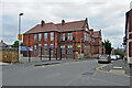
The back of Berridge Primary and Nursery School
Where I was here in the 1950s, infant classes were in the building to the left and juniors on the top floor of the larger building in the background, which fronts Berridge Road. The last few classes of Berridge Elementary for Boys were on the ground floor until the last of them left at 14, I think in the mid fifties. By then a lot of secondary-modern schools and two new grammar schools had been built to cater for the post-war bulge.
Image: © John Sutton
Taken: 5 May 2018
0.04 miles
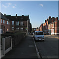
7
Kenslow Avenue
Looking towards Berridge Road West on a bright late-September morning.
Image: © John Sutton
Taken: 25 Sep 2015
0.04 miles
8
Berridge Road West and Berridge Primary School
Bright sunlight and strong shadow at twenty-past nine on a late-September morning. The school looks much as it did when I learned lots of things there in the 1950s.
Image: © John Sutton
Taken: 25 Sep 2015
0.05 miles
9
Berridge Road Junior School, 1993
Looking much the same as it had when I was a pupil in the 1950s - though there were no trees in the infants' playground then, and all the doors were painted municipal green.
Image: © John Sutton
Taken: 13 Mar 1993
0.05 miles
10
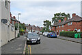
Oakland Street
Looking from Berridge Road West to Bobbers Mill Road.
Image: © John Sutton
Taken: 24 Sep 2009
0.06 miles