IMAGES TAKEN NEAR TO
Gauntley Street, NOTTINGHAM, NG7 5HF
Introduction
This page details the photographs taken nearby to Gauntley Street, NG7 5HF by members of the Geograph project.
The Geograph project started in 2005 with the aim of publishing, organising and preserving representative images for every square kilometre of Great Britain, Ireland and the Isle of Man.

There are currently over 7.5m images from over14,400 individuals and you can help contribute to the project by visiting https://www.geograph.org.uk
Image Map (Loading...)


Getting Data...Please wait
Leaflet Map data © OpenStreetMap
Images are licensed for reuse under creativecommons.org/licenses/by-sa/2.0
Notes
- Clicking on the map will re-center to the selected point.
- The higher the marker number, the further away the image location is from the centre of the postcode.
Image Listing (228 Images Found)
Images are licensed for reuse under creativecommons.org/licenses/by-sa/2.0
Image
Details
Distance
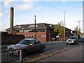
1

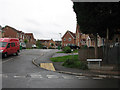
Gauntley Street
A new street, The Poplars, is ahead to the right. The long dark roof in the centre is of the Churchside Gardens development off Bobbers Mill Road, with the spiky spire of St Stephen's Church to its left, above the backs of the houses on Ashwell Gardens.
Image: © John Sutton
Taken: 16 Apr 2010
0.03 miles
2
The Poplars
A new development leading on from Victorian Gauntley Street. The re-routed Plantation Side footpath (signposted, though the green finger is scarcely visible, next to the lamp post, in this picture) comes out between the houses on the right, where the green wheelie bin and the black car are.
Image: © John Sutton
Taken: 12 Aug 2009
0.03 miles
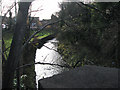
3
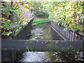
River Leen
Looking south from Gauntley Street.
Image: © John Sutton
Taken: 25 Sep 2009
0.04 miles
4
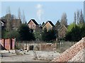
Gerard's, Field Maple Drive and the Ratcliffe plume
A slightly foreshortened view from Wilkinson Street. In the foreground are some of the remains of Gerard's Soap Works, demolished in 2011. The plume from Ratcliffe-on-Soar Power Station, eight miles or so away, shows above two of the houses of Field Maple Drive.
Image: © John Sutton
Taken: 1 May 2013
0.04 miles
5
Gerard's Soap Works
Part of the derelict soap factory.
Image: © John Sutton
Taken: 25 Sep 2009
0.05 miles
6

River Leen at Bobbers Mill
The river flows behind the new houses on the west side of The Poplars. I think this little path to nowhere was the Plantation Side footpath before it was re-routed when The Poplars was built. The green railings http://www.geograph.org.uk/photo/1507507 in the middle distance mark the present path, emerging from between the houses and following the river.
Image: © John Sutton
Taken: 16 Apr 2010
0.06 miles
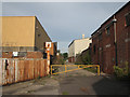
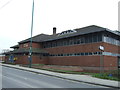
7
Radford Road Police Station
On the corner of Ward Street. The original Hyson Green police station was on the corner of Gregory Boulevard and Radford Road.
Image: © John Sutton
Taken: 20 Nov 2009
0.06 miles
9
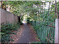
Plantation Side - 5
The twitchel beside the River Leen, between The Poplars and Meadow Brown Road.
Image: © John Sutton
Taken: 25 Sep 2009
0.07 miles
10
Radford Road Police Station, Hyson Green, Nottingham
Image: © JThomas
Taken: 27 Mar 2017
0.07 miles