IMAGES TAKEN NEAR TO
Oliver Street, NOTTINGHAM, NG7 4HA
Introduction
This page details the photographs taken nearby to Oliver Street, NG7 4HA by members of the Geograph project.
The Geograph project started in 2005 with the aim of publishing, organising and preserving representative images for every square kilometre of Great Britain, Ireland and the Isle of Man.

There are currently over 7.5m images from over14,400 individuals and you can help contribute to the project by visiting https://www.geograph.org.uk
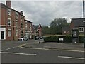
Image Map
Images are licensed for reuse under creativecommons.org/licenses/by-sa/2.0
Notes
- Clicking on the map will re-center to the selected point.
- The higher the marker number, the further away the image location is from the centre of the postcode.
Image Listing (434 Images Found)
Images are licensed for reuse under creativecommons.org/licenses/by-sa/2.0
Image
Details
Distance
3

Benchmark on cemetery wall on SE side of Cromwell Street
Ordnance Survey cut mark benchmark described on the Bench Mark Database at www.bench-marks.org.uk/bm111713
Image: © Luke Shaw
Taken: 14 Sep 2019
0.05 miles
4
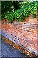
Cemetery wall on SE side of Cromwell Street
There is an Ordnance Survey benchmark Image cut into bricks of the wall
Image: © Luke Shaw
Taken: 14 Sep 2019
0.05 miles
5

Cemetery wall on SE side of Cromwell Street
There is an Ordnance Survey benchmark Image on the wall on bricks 10 from the right hand edge of the image
Image: © Luke Shaw
Taken: 14 Sep 2019
0.06 miles
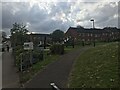
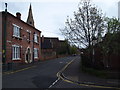
6
Raleigh Street
The prosperous mid-Victorian streets west of The Arboretum are behind the camera. The recent developments in the distance, towards Alfreton Road, replaced humbler terraces. All Saints' church gate and the former church school are on the right.
Image: © John Sutton
Taken: 14 Sep 2012
0.07 miles
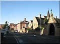
7
Nottingham - NG7
A glance down Raleigh St from the junction with Walter Rd shows an older property and then beyond it, the pitched roofs of the former All Saints' Church school and the spire of the Church. Having been advised by his doctor that he only had 6 mths to live and should consider cycling as a remedial measure Frank Bowden bought a bicycle from a small shop somewhere on Raleigh Street run by Messrs Woodhead, Angois and Ellis. Once on the road to recovery he bought them out and the rest, as they say, is history.
Image: © David Hallam-Jones
Taken: 28 Apr 2012
0.07 miles
8
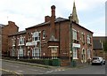
St Mary's House, Raleigh Street, Nottingham
Built In 1870 by Thomas Hine, a renowned local architect, for his son G T Hine. Listed Grade II. After a period as a hostel, it was reconfigured as small flats, following the original interior layout. A number of original features such as fireplaces still exist.
Image: © Alan Murray-Rust
Taken: 12 Aug 2019
0.07 miles
9
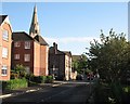
Raleigh Street and All Saints' spire
Looking towards Waverley Street and The Arboretum on a bright September morning.
Image: © John Sutton
Taken: 14 Sep 2012
0.07 miles
10
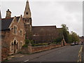
Nottingham - NG7
A view along Raleigh Street in the general direction of Waverley Street and the Arboretum. The building in the foreground is part of the former All Saints’ School and St Andrew’s Anglican Church is beyond it. The school ceased to operate as such in 1905 and the buildings have been used for different purposes by the Church and the community over the years. All the buildings on the site including the church, the vicarage, the school and a headmaster's house were designed by T.C. Hine and the project was paid for by William Windley, a Nottingham magistrate.
Image: © David Hallam-Jones
Taken: 28 Apr 2012
0.07 miles