IMAGES TAKEN NEAR TO
All Saints Terrace, NOTTINGHAM, NG7 4DQ
Introduction
This page details the photographs taken nearby to All Saints Terrace, NG7 4DQ by members of the Geograph project.
The Geograph project started in 2005 with the aim of publishing, organising and preserving representative images for every square kilometre of Great Britain, Ireland and the Isle of Man.

There are currently over 7.5m images from over14,400 individuals and you can help contribute to the project by visiting https://www.geograph.org.uk
Image Map
Images are licensed for reuse under creativecommons.org/licenses/by-sa/2.0
Notes
- Clicking on the map will re-center to the selected point.
- The higher the marker number, the further away the image location is from the centre of the postcode.
Image Listing (319 Images Found)
Images are licensed for reuse under creativecommons.org/licenses/by-sa/2.0
Image
Details
Distance
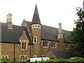
1
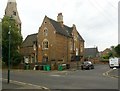
All Saints Vicarage, John Perkins House, Nottingham
Built 1863-4 by Thomas Hine as the vicarage to All Saints Church. In the late 20th century part of the house was converted to provide a Community House, under the aegis of TocH, for students with a Christian outlook. Listed Grade II.
Image: © Alan Murray-Rust
Taken: 26 Jul 2019
0.02 miles
2
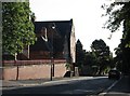
Former All Saints Church Schools
Built 1864-5 by Thomas Hine as part of the development of All Saints Church when the whole area was being developed by Nottingham lace manufacturer William Windley who financed the scheme. There were several schoolrooms providing for the general education of children of the area. Now converted to local community workshops. Listed Grade II.
Image: © Alan Murray-Rust
Taken: 26 Jul 2019
0.02 miles
3
A September morning in All Saints Street
A view into the sun from the corner of Tennyson Street. Nottingham's first suburbs were developed to the north-west of the city centre in the thirty or so years after the 1845 Enclosure Act.
Image: © John Sutton
Taken: 14 Sep 2012
0.03 miles
4
All Saints, Nottingham
For a wider view see Image
Image: © David Lally
Taken: 6 Mar 2008
0.03 miles
5
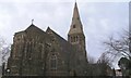
All Saints, All Saints Street, Nottingham
Built in 1864 All Saints is an imposing example of Victorian Gothic. There are a few other churches built of similar light-coloured stone in the 19th century around Nottingham. Perhaps most notably Image
Image: © David Lally
Taken: 6 Mar 2008
0.03 miles
6
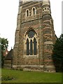
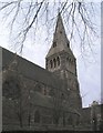
Church of All Saints, Raleigh Street
West window and base of the tower. See http://www.geograph.org.uk/photo/6229855 for more details.
Image: © Alan Murray-Rust
Taken: 26 Jul 2019
0.03 miles
7
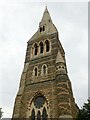
Church of All Saints, Raleigh Street
The tower and spire.
See http://www.geograph.org.uk/photo/6229855 for more details.
Image: © Alan Murray-Rust
Taken: 26 Jul 2019
0.03 miles
8
Former All Saints Church Schools
Built 1864-5 by Thomas Hine as part of the development of All Saints Church when the whole area was being developed by Nottingham lace manufacturer William Windley who financed the scheme. There were several schoolrooms providing for the general education of children of the area. Now converted to local community workshops. Listed Grade II.
Image: © Alan Murray-Rust
Taken: 26 Jul 2019
0.04 miles
9
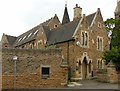
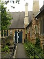
Schoolmaster's house, former All Saints School, Raleigh Street
Part of the extensive development by Thomas Hine based on the new All Saints Church of 1863-5, it provided accommodation for teacher at the school which was part of the development. Listed Grade II separately from the school which can be seen behind. Now part of a community centre with community workspaces.
Image: © Alan Murray-Rust
Taken: 26 Jul 2019
0.04 miles
10
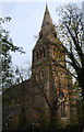
All Saints Church from All Saints Street
The spire is an Ordnance Survey intersected station trig point, http://trigpointing.uk/trig/11388
Image: © Roger Templeman
Taken: 3 Nov 2017
0.04 miles