IMAGES TAKEN NEAR TO
Grove Avenue, NOTTINGHAM, NG7 4BP
Introduction
This page details the photographs taken nearby to Grove Avenue, NG7 4BP by members of the Geograph project.
The Geograph project started in 2005 with the aim of publishing, organising and preserving representative images for every square kilometre of Great Britain, Ireland and the Isle of Man.

There are currently over 7.5m images from over14,400 individuals and you can help contribute to the project by visiting https://www.geograph.org.uk
Image Map
Images are licensed for reuse under creativecommons.org/licenses/by-sa/2.0
Notes
- Clicking on the map will re-center to the selected point.
- The higher the marker number, the further away the image location is from the centre of the postcode.
Image Listing (247 Images Found)
Images are licensed for reuse under creativecommons.org/licenses/by-sa/2.0
Image
Details
Distance
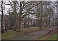
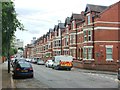
2
Hardy Street
Leafy Hardy Street runs parallel to Waterloo Crescent from Southey Street to Mount Hooton Road and serves some of the quite grand detached houses built in the middle years of the nineteenth century as Nottingham expanded beyond its mediaeval core after the 1845 Enclosure Act.
Image: © John Sutton
Taken: 21 Jun 2017
0.04 miles
3
Waterloo Crescent
One of the grander late Victorian developments on the edge of Radford.
Image: © John Sutton
Taken: 26 Aug 2010
0.05 miles
4
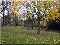
Waterloo Crescent on a January afternoon
Nottingham’s Victorian planners established a number of tree-lined promenades in what were then some of the most fashionable suburbs. Such walks were seen as an alternative to the “drinking shops, where, in short-lived excitement, [working men] may forget their toil, but where they waste the means of their families and too often destroy their health”.
Image]
Image]
Image]
Image]
Image: © John Sutton
Taken: 23 Jan 2017
0.05 miles
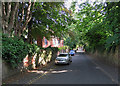
5
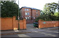
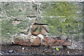
Brick walls at entrance to 36 Bentinck Road
The Ordnance Survey cut a benchmark on the wall in 1962 and levelled it at 53.499m above Newlyn Datum: see www.bench-marks.org.uk/bm111705 for details. Apparently the walls have been rebuilt.
Image: © Luke Shaw
Taken: 14 Sep 2019
0.05 miles
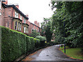
6
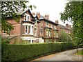
Houses on Waterloo Crescent
Mid 19th century villas on what would have been a sought-after location when built in the mid 19th century.
Image: © Alan Murray-Rust
Taken: 12 Aug 2019
0.05 miles
7
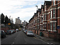
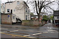
Bentinck Road
The bus is waiting at the traffic lights at the top of Radford Road. The tower blocks in the distance are on Hartley Road.
Image: © John Sutton
Taken: 20 Nov 2009
0.06 miles
9
Benchmark on the wall of Mount Hooton Road
Ordnance Survey cut mark benchmark described on the Bench Mark Database at http://www.bench-marks.org.uk/bm42611
Image: © Roger Templeman
Taken: 9 Apr 2012
0.07 miles
10
Junction of Mount Hooton Road and Weston Avenue
There is an OS benchmark Image on the corner of the wall
Image: © Roger Templeman
Taken: 9 Apr 2012
0.07 miles