IMAGES TAKEN NEAR TO
Ortzen Street, NOTTINGHAM, NG7 4BF
Introduction
This page details the photographs taken nearby to Ortzen Street, NG7 4BF by members of the Geograph project.
The Geograph project started in 2005 with the aim of publishing, organising and preserving representative images for every square kilometre of Great Britain, Ireland and the Isle of Man.

There are currently over 7.5m images from over14,400 individuals and you can help contribute to the project by visiting https://www.geograph.org.uk
Image Map
Images are licensed for reuse under creativecommons.org/licenses/by-sa/2.0
Notes
- Clicking on the map will re-center to the selected point.
- The higher the marker number, the further away the image location is from the centre of the postcode.
Image Listing (150 Images Found)
Images are licensed for reuse under creativecommons.org/licenses/by-sa/2.0
Image
Details
Distance
1
Benchmark on #36 Peveril Street
Ordnance Survey cut mark benchmark described on the Bench Mark Database at http://www.bench-marks.org.uk/bm35204.
Image: © Roger Templeman
Taken: 10 Aug 2010
0.03 miles
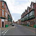
2
Peveril Street
Looking north towards Bentinck Road and Hyson Green.
Image: © John Sutton
Taken: 16 Apr 2010
0.04 miles
3
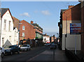
Alfreton Road and Peveril Street
The distinctive former bank is wedged between Alfreton Road (left) and Peveril Street. At 8.40 on a September morning most of the traffic is heading for the city.
Image: © John Sutton
Taken: 14 Sep 2012
0.04 miles
4

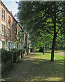
Waterloo Promenade
Like Forest Fields, this was one of the more genteel late Victorian developments in the parish of Radford.
Image: © John Sutton
Taken: 26 Aug 2010
0.04 miles
5
Waterloo Promenade
Enlightened town planning in Victorian Nottingham.
Image: © John Sutton
Taken: 21 Jun 2017
0.06 miles
6
Radford: up Peveril Street
Looking towards Alfreton Road on a cloudy August afternoon. Though Victorian three-storey terraces are common, the wooden first-floor oriel windows are unusual for Nottingham.
Image: © John Sutton
Taken: 25 Aug 2021
0.06 miles
7
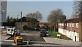
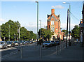
Independent Street
This picture is taken across Alfreton Road from Peveril Street, the photographer standing unsteadily on a pallet-load of bricks in order to include sixteenth-century Wollaton Hall on the horizon two miles away (the pale blob just to the right of centre, above the line of cars). One of several tower blocks in this part of Radford edges into the left of the picture.
Image: © John Sutton
Taken: 16 Apr 2010
0.08 miles
9
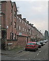
Limpenny Street
The backs of houses on Waterloo Promenade, photographed on a drab winter afternoon.
Image: © John Sutton
Taken: 23 Jan 2017
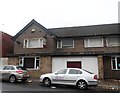
0.08 miles
10
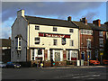
The Alma Inn
The name dates this pub to the period immediately following the Crimean War. Of particular interest however is the adjacent house which retains its top-storey framework knitters windows, the only remaining example in Nottingham.
Image: © Alan Murray-Rust
Taken: 7 Nov 2008
0.09 miles