IMAGES TAKEN NEAR TO
Montgomery Street, NOTTINGHAM, NG7 4AQ
Introduction
This page details the photographs taken nearby to Montgomery Street, NG7 4AQ by members of the Geograph project.
The Geograph project started in 2005 with the aim of publishing, organising and preserving representative images for every square kilometre of Great Britain, Ireland and the Isle of Man.

There are currently over 7.5m images from over14,400 individuals and you can help contribute to the project by visiting https://www.geograph.org.uk
Image Map
Images are licensed for reuse under creativecommons.org/licenses/by-sa/2.0
Notes
- Clicking on the map will re-center to the selected point.
- The higher the marker number, the further away the image location is from the centre of the postcode.
Image Listing (343 Images Found)
Images are licensed for reuse under creativecommons.org/licenses/by-sa/2.0
Image
Details
Distance
1
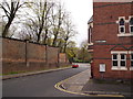
Nottingham - N7
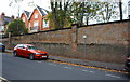
Looking down Burns Street towards Waverley St, on which the Arboretum lies. The high wall is a boundary wall of Waverley House School, an independent PNEU-orientated preparatory day school for boys and girls of between 3-11 yrs. Parents’ National Education Union schools arose from the work and teachings of the Welsh liberal educator Charlotte Mason (1842-1923). Mason taught at the Bishop Otter Teacher Training College in Chichester and Parents' Educational Union schools (later to become known as PNEU schools) arose from her particular educational philosophy.
Image: © David Hallam-Jones
Taken: 28 Apr 2012
0.01 miles
2
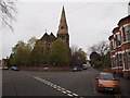
Nottingham - NG7
All Saints' Anglican Church occupies this a prime site between Raleigh St and All Saints’ Street. It dates from 1864 when new houses were being built when the older parts of the city were permitted to expand. The church, plus the vicarage, a school and a headmaster's house - all on the same site - were designed by T.C. Hine and paid for by William Windley, a Nottingham magistrate. The former school can be seen on the left-hand margin of the picture although it ceased to function in 1905. The school premises are currently owned by a Nigerian congregation.
Image: © David Hallam-Jones
Taken: 28 Apr 2012
0.02 miles
3
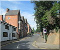
Burns Street
When Nottingham expanded beyond its mediaeval core after the Enclosure Act of 1845, some of the first suburbs were built in the area north of the city centre, between Alfreton and Mansfield Roads, with the grander houses in the streets near All Saints' Church.
Image: © John Sutton
Taken: 23 Aug 2013
0.02 miles
5
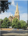
Nottingham: All Saints
The church was built in 1863-4 to serve the prosperous suburb which developed north of the city centre after the Enclosure Act of 1845. "Gothic, rock-faced stone with bands of red Mansfield and cream Little Eaton ashlar. Apsidal chancel, with N chapel and S vestry" (Elain Harwood in the Pevsner Architectural Guide to Nottingham). This is a view from the east end of Raleigh Street on a bright August morning.
Image: © John Sutton
Taken: 23 Aug 2013
0.03 miles
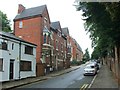
6
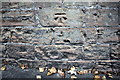
Benchmark on wall of Burns Street
Ordnance Survey cut mark benchmark described on the Bench Mark Database at http://www.bench-marks.org.uk/bm90313
Image: © Roger Templeman
Taken: 3 Nov 2017
0.03 miles
7
Boundary wall of school on north side of Burns Street
There is an OS benchmark Image on the wall about 2m right of the parking sign pole
Image: © Roger Templeman
Taken: 3 Nov 2017
0.03 miles
8

Church of All Saints, Raleigh Street
Detail of the apse with dragon gargoyle.
See http://www.geograph.org.uk/photo/6229855 for location and http://southwellchurches.history.nottingham.ac.uk/nottingham-all-saints/hintro.php for details.
Image: © Alan Murray-Rust
Taken: 26 Jul 2019
0.04 miles
9
Western side of the Arboretum, Nottingham
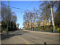
Waverley Street passes the western edge of the Arboretum that gives this part of Nottingham its name, and is the route by which the Nottingham Express Transit tramway enters Nottingham city centre from the north. Part of Nottingham High School, an independent boys' day school which celebrates its 500th anniversary in 2013, is visible beyond the Arboretum itself.
Image: © Richard Vince
Taken: 4 Feb 2013
0.04 miles
10
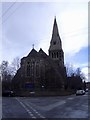
All Saints' Church, Nottingham
Designed by Thomas Chambers Hine, 1863-64.
Image: © Andrew Abbott
Taken: 11 Apr 2008
0.04 miles