IMAGES TAKEN NEAR TO
Moorgate Street, NOTTINGHAM, NG7 3QG
Introduction
This page details the photographs taken nearby to Moorgate Street, NG7 3QG by members of the Geograph project.
The Geograph project started in 2005 with the aim of publishing, organising and preserving representative images for every square kilometre of Great Britain, Ireland and the Isle of Man.

There are currently over 7.5m images from over14,400 individuals and you can help contribute to the project by visiting https://www.geograph.org.uk
Image Map
Images are licensed for reuse under creativecommons.org/licenses/by-sa/2.0
Notes
- Clicking on the map will re-center to the selected point.
- The higher the marker number, the further away the image location is from the centre of the postcode.
Image Listing (318 Images Found)
Images are licensed for reuse under creativecommons.org/licenses/by-sa/2.0
Image
Details
Distance
4
Nottingham - NG7
This derelict mill-related building on Alfreton Road (A610) ended its days hosting the P.O.W Project (Prostitute Outreach Workers' project) during the late 80s and some of the 90s, on a low rent or gratis basis.
Image: © David Hallam-Jones
Taken: 28 Apr 2012
0.06 miles
5
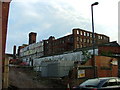
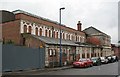
Forest Mills
Textile Mill situated between Alfreton Road, Boden Street, Thackeray Street, Denman Street East (from where this image was taken) and Highurst Street. An adjoining building has recently been demolished and the pitched roof has been removed, to be replaced with a flat one. Also various repair works are to take place to the wall (according to recent planning applications). However, an aim of the council seems to be demolition...
Image: © Matt Nicholas
Taken: 21 Oct 2006
0.07 miles
6
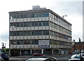
Former offices, Alfreton Road, Nottingham
This 1960s gem has since been demolished (Image]). It appeared to be the office range of Forest Mill.
Image: © Stephen Richards
Taken: 19 Jun 2015
0.07 miles
8
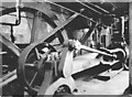
Gamble's Factory, steam engine
This was a real discovery when it crawled out of the woodwork in 1980. It's an 1873 Hick, Hargreaves Corliss engine with Spencer Inglis double clip trip gear. It's also a rare UK example of a single eccentric Corliss (enough technical stuff!).
Anyway, it's now on display at Forncett Industrial Steam Museum in Norfolk.
Image: © Chris Allen
Taken: 15 Dec 1980
0.08 miles
9
Former Baths buildings, Thackeray Street
This range of buildings was more or less attached to the Forest Mills complex, and appeared to be part of it. However, recently paint has started peeling on the part of the building with the two-storey facade, revealing the lettering 'Gentlemen's Baths and Ladies' Baths'. The fate of the building is unknown.
Image: © Alan Murray-Rust
Taken: 22 Jun 2007
0.08 miles
10
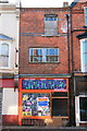
Derelict Shop on Alfreton Road
Not a rare sight.
This appears to have been a fast-food outlet most recently.
The small red writing on the sign says Chicken Hut (above the door) and New York Paris Radford (across the top).
Let's hope the New York and Paris branches are more successful!
Image: © David Lally
Taken: 7 Nov 2008
0.08 miles