IMAGES TAKEN NEAR TO
Midland Way, NOTTINGHAM, NG7 3NY
Introduction
This page details the photographs taken nearby to Midland Way, NG7 3NY by members of the Geograph project.
The Geograph project started in 2005 with the aim of publishing, organising and preserving representative images for every square kilometre of Great Britain, Ireland and the Isle of Man.

There are currently over 7.5m images from over14,400 individuals and you can help contribute to the project by visiting https://www.geograph.org.uk
Image Map
Images are licensed for reuse under creativecommons.org/licenses/by-sa/2.0
Notes
- Clicking on the map will re-center to the selected point.
- The higher the marker number, the further away the image location is from the centre of the postcode.
Image Listing (150 Images Found)
Images are licensed for reuse under creativecommons.org/licenses/by-sa/2.0
Image
Details
Distance
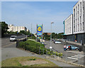
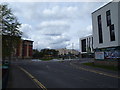
1
Lidl, Radford
On Midland Way, Radford
Image: © Andrew Abbott
Taken: 31 Jan 2021
0.01 miles
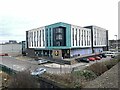
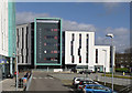
2
Opal 1 and the corner of St Peter's Street
New student flats at the corner of Wollaton Road and St Peter's Street. The land, to the east of the former Radford railway station, was once occupied by the railway, Chettle's and Butterworth & Walker, as older Radfordians will remember. Nottingham University's Jubilee Campus is nearby.
Image: © John Sutton
Taken: 11 May 2012
0.01 miles
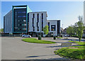
3
Opal 1, Wollaton Road
New student flats at the corner of Wollaton Road and St Peter's Street. The land was once occupied by the railway, Chettle's and Butterworth & Walker, as older Radfordians will remember.
Image: © John Sutton
Taken: 20 Nov 2009
0.02 miles
4
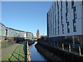
Part of the River Leen in Radford, Nottingham
The river looks like a section of old canal a bit here, but there is no towpath.
Image: © Jeremy Bolwell
Taken: 19 Jan 2020
0.03 miles
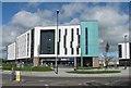
5
Nottingham 1
This is the main reception building of a large development of student accommodation on a former industrial estate.
Image: © Alan Murray-Rust
Taken: 16 Feb 2014
0.04 miles
6
Old Radford: Nottingham Two
A block of student flats near the southern end of St Peter's Street (right) and convenient for Nottingham University's Jubilee Campus. It was built on a brownfield site which I remember being partly occupied by the yard and garages of Butterworth & Walker, used-car dealers - but that was fifty or sixty years ago.
Image: © John Sutton
Taken: 5 May 2018
0.04 miles
7
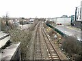
Site of Radford railway station
Opened by the Midland Railway in 1848. Closed in 1964.
Image: © Andrew Abbott
Taken: 31 Jan 2021
0.04 miles
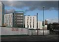
8
Midland Way Retail
The Opal 1 student flats are on the right (Nottingham University's Jubilee Campus is nearby). Wollaton Road rises to cross the railway at the site of Radford Station (closed 1964). The Midland Railway built this line and (presumably) gives its name to the shops and burger joints here. Beyond the railway, on the left, is the former Player's Bonded Warehouse, which was about to be demolished when this picture was taken.
Image: © John Sutton
Taken: 21 Jun 2017
0.05 miles
9
Nottingham - NG7 (Lenton)
This is the view at the Faraday Road end of St Peter's Street. The brown building behind the trees is Sillitoe Court (named after Alan Sillitoe, the author) and facing the side of this 7-storey student accommodation block is the former White Horse pub that is referred to in the book and film "Saturday Night & Sunday Morning". "Opal 1" is being marketed as (private) "premium grade" student accommodation.
Image: © David Hallam-Jones
Taken: 5 May 2012
0.05 miles
10
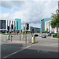
At the bottom of Ilkeston Road
This is the crossroads where Faraday Road and Wollaton Road (left), St Peter's Street (ahead) and Ilkeston Road (right) meet. In recent years brownfield sites have been redeveloped as student accommodation - Nottingham University's Jubilee Campus is nearby.
Image: © John Sutton
Taken: 24 Aug 2017
0.05 miles