IMAGES TAKEN NEAR TO
Holden Street, NOTTINGHAM, NG7 3JN
Introduction
This page details the photographs taken nearby to Holden Street, NG7 3JN by members of the Geograph project.
The Geograph project started in 2005 with the aim of publishing, organising and preserving representative images for every square kilometre of Great Britain, Ireland and the Isle of Man.

There are currently over 7.5m images from over14,400 individuals and you can help contribute to the project by visiting https://www.geograph.org.uk
Image Map (Loading...)


Getting Data...Please wait
Leaflet Map data © OpenStreetMap
Images are licensed for reuse under creativecommons.org/licenses/by-sa/2.0
Notes
- Clicking on the map will re-center to the selected point.
- The higher the marker number, the further away the image location is from the centre of the postcode.
Image Listing (405 Images Found)
Images are licensed for reuse under creativecommons.org/licenses/by-sa/2.0
Image
Details
Distance
1
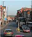
Down Alfreton Road
A view from Canning Circus, taken from the top deck of a 77 bus to Strelley on a bright late-September morning.
Image: © John Sutton
Taken: 25 Sep 2015
0.01 miles
2
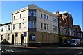
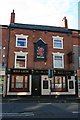
The ex-Rose and Crown
On Alfreton Road, Nottingham.
Not been a pub for at least four years, but retains the name plaque above what was the door.
Image: © David Lally
Taken: 7 Nov 2008
0.02 miles
3
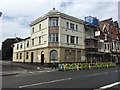
The ex Rose and Crown being refurbished?
Either that or just having some roof maintenance. I last took this view in 2008 Image
Image: © David Lally
Taken: 6 Jul 2017
0.02 miles
4
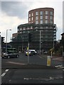
New apartment block at Canning Circus
At the top of Ilkeston Road. A very attractive building in my opinion. Replacing a former pub / club of various names and a not uninteresting design: Image
Image: © David Lally
Taken: 26 Jul 2018
0.03 miles
5
Nottingham - NG7
The main entrance of the General Cemetery on Alfreton Road (the A610), i.e. on one side of Canning Circus. The entrance is flanked by six former almshouses (in two wings). The Freemen's Houses, as they were known, were built to house aged freemen (a.k.a. town burgesses) and their widows. They were built between 1837-1840 by Elliott, Greasley and Whitworth to a design by Mr S. Sutton Rawlinson. This Grade II-listed building "in debased Classical style was restored circa 1985. The gatehouse is described as “having a recessed rusticated centre with a round carriage arch under a dentillated cornice and the central square clock tower as being “topped by a round-arched bell turret with cross pediments”. The cemetery, created by the Nottingham General Cemetery Company in 1836, was originally set aside for Anglicans, although an extension was created for non-conformists in 1865. The almshouses are now rented out to non-almshouse tenants. Nottingham City Council took over ownership of the site in 1956.
Image: © David Hallam-Jones
Taken: 28 Apr 2012
0.04 miles
6
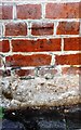
Benchmark on The Running Horse pub, Alfreton Road (Cromwell Street face)
Ordnance Survey cut mark benchmark described on the Bench Mark Database at www.bench-marks.org.uk/bm111711
Image: © Luke Shaw
Taken: 14 Sep 2019
0.04 miles
7
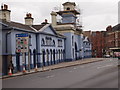
The Running Horse
One of several pubs close to Canning Circus. This retains its ornate terracotta façade unaltered.
Image: © Alan Murray-Rust
Taken: 22 Dec 2013
0.04 miles
8
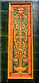
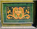
Tile detail on the Running Horse
The pub is now closed (see Image). One wonders what will happen to it and if its tiled exterior will survive.
Image: © David Lally
Taken: 14 Apr 2010
0.04 miles
9
Tile detail on the Running Horse
The pub is now closed (see Image). One wonders what will happen to it and if its tiled exterior will survive.
Image: © David Lally
Taken: 14 Apr 2010
0.04 miles
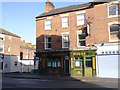
10
The Red Lion
On Alfreton Road.
With a striking frontage sign.
Image: © David Lally
Taken: 7 Nov 2008
0.04 miles