IMAGES TAKEN NEAR TO
Norwood Road, NOTTINGHAM, NG7 3FJ
Introduction
This page details the photographs taken nearby to Norwood Road, NG7 3FJ by members of the Geograph project.
The Geograph project started in 2005 with the aim of publishing, organising and preserving representative images for every square kilometre of Great Britain, Ireland and the Isle of Man.

There are currently over 7.5m images from over14,400 individuals and you can help contribute to the project by visiting https://www.geograph.org.uk
Image Map
Images are licensed for reuse under creativecommons.org/licenses/by-sa/2.0
Notes
- Clicking on the map will re-center to the selected point.
- The higher the marker number, the further away the image location is from the centre of the postcode.
Image Listing (165 Images Found)
Images are licensed for reuse under creativecommons.org/licenses/by-sa/2.0
Image
Details
Distance
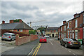
1
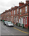
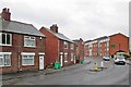
Old Radford: Norwood Road
A typical red-brick terrace. In years gone by many of the people who lived here would have worked in the nearby cigarette, cycle and hosiery factories. Parts of Radford were cleared in the 1970s and new houses and flats built.
Image: © John Sutton
Taken: 2 Jun 2015
0.01 miles
2
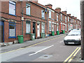
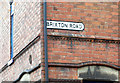
Brixton Road, Radford
Two storey plane-fronted terraces like this are not a common sight in Nottingham.
Image: © David Lally
Taken: 15 Mar 2008
0.04 miles
3
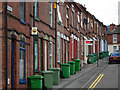
Brixton Road, Radford
Much of the Radford area traditionally consisted of red brick Victorian terraced houses occupied by workers at either the Raleigh bicycle factory or Player's cigarettes. Many of the streets were demolished and redeveloped in the 1970s, but Brixton Road - now sporting a fine display of green wheelie bins - has survived.
Image: © Stephen McKay
Taken: 3 Jul 2008
0.04 miles
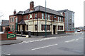
5
Old Radford: down Brixton Road
Looking towards St Peter's Street and The Plough public house on a cloudy August afternoon. Nottingham Brewery is based at The Plough. The crane is on a site where new student flats are going up.
Image: © John Sutton
Taken: 25 Aug 2021
0.04 miles
6
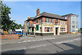
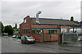
The Plough, St Peter's Street
In my childhood this was a Tennants pub. It now houses a microbrewery which revives the Nottingham Brewery name lost when Tennants bought the company. David Lally's Image] was taken in 2008.
Image: © John Sutton
Taken: 21 Jun 2017
0.04 miles
7
The Plough, St Peter's Street, Radford
Home of the Nottingham Brewery. https://www.thenottinghambrewery.co.uk
Image: © David Lally
Taken: 15 Mar 2008
0.05 miles
8
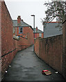
A Radford twitchel
A gloomy April morning in Old Radford. This twitchel links Hartley Road to Lonsdale Road (ahead).
Image: © John Sutton
Taken: 12 Apr 2016
0.06 miles
9
Old Radford: a wet morning in St Peter's Street
A view from the corner of Hartley Road and New Road. Formerly an exclusively working-class district of terraced streets, textile factories and workshops of various kinds, Old Radford is now home to a lot of student accommodation like the flats to the right.
Image: © John Sutton
Taken: 2 Jun 2015
0.06 miles
10
Old Radford: workshop on St Peter's Street
Bennett's Designers & Cabinet Makers Ltd at the corner of St Peter's Street and Hartley Road, photographed on a wet June morning. The security gates on the right are on the site of Radford Workhouse, a picturesque brick building completed in 1732 but not considered worth saving when it was demolished c 1970. For more about it, and a picture, see http://www.nottsheritagegateway.org.uk/themes/poverty.htm .
Image: © John Sutton
Taken: 2 Jun 2015
0.07 miles